Tuesday, August 28, 2007
Monday, August 27, 2007
Maineiacs spend two unscheduled days in Orono
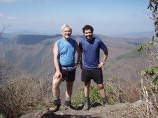
Uno and Dewey expect to resume the trail tomorrow to complete the remaining 170 miles of the AT to Mt. Katahdin, after making and unexpected two day recovery back in the comfort of home, after Dewey tried to perform do it yourself leg surgery with a dull rock on the summit of Mt. Avery. Up to this point, due the difficulty of the frustrating terrain,and wet humid slippery conditions, Dewey had been cursing Myron Avery in fact for ever having pushed the trail through to Maine in the first place. He apparently got his answer.
The home state has continued to be a challenge for the thru-hikers. In the last three days before reaching Sugarloaf, we did three 10 mile days; but each day included scaling at least two four thousand foot peaks, not a trivial endeavor. Of the twelve 4,000 ft peaks in Maine, the trail manages to climb all but four in the western part of the state. With the completion of West and Avery peaks, we won't see that elevation again until Baxter. We spent one night in the summit lodge on Sugarloaf, easily accessed by a half mile spur trail off the AT. The building is left open especially for thru-hikers to use as a shelter. We thought we had the place to ourselves until 7:30pm, when 6 college students arrived in a pick-up truck, having driven up the cat access road, loaded with plenty of party materials and a tent which they proceeded to set up in the building. They were actually quite nice and offered us a beer, at least recognizing that the way to a thru-hiker's heart is through his stomach and love of beer.
The following day we descended Sugarloaf in a 20mph winds with rain and fog, only to climb the other side of the Caribou Valley over the Crocker Mountains. These have wooded summits, no views and add at least 3 miles to the trail before reaching route 27. Reaching the road finally at least we were rewarded by meeting Kathy and staying the night at a condo owned again by our good friends the Boleys (of Lancaster PA fame.) After showers and shopping in the lovely metropolis of Stratton, we enjoyed a nice repast at Hugs Italian Restaurant that evening.
The next day we had a slow start, lacking in general motivation , but managed to get ourselves on the trail by 11am. It was warm but very humid as we set out to complete 15 miles to Little Bigelow shelter over the Horn Peaks, West Peak and Avery. Because of the humidity and a brief shower the rocks remained extremely slippery and at times it felt like walking on ice. These were the conditions which set Dewey up 'for the fall' on the summit of Avery, gashing his lower leg. Despite the injury he got up and was able to complete the 7 miles to the shelter, but in the process the front half of his calf swelled to twice it's size, making walking a challenge. We finally managed to get into the shelter, literally minutes ahead of a deluge and lightning storm that had been threatening us for two hours while we walked along the ridge. We called the nurse-pit crew who returned the following morning and picked us up near Flagstaff Lake.
At this point we have passed the 2000 mile mark and have seen Katahdin from the summit of Saddleback Junior. With any luck, we expect to summit Thursday or Friday next week after Labor Day, weather permitting. We'll have more updates if there is any internet access in Monson. Otherwise the final chapter will be written after we complete the hike next week.
Sunday, August 19, 2007
Maineiacs home in Maine
Dewy and I continue our trek to Katahdin, with approximately 245 miles to go and continuing. We are spending the second of two nights at The Andover Guest House in Andover, Maine, which has been a great hostel for us to stop and rest. Today, with full packs, we hiked 10 miles from the Andover 'B' road to South Arm Road, with the intent of spending two nights here. I'm trying to get over a cold with bronchitis, and camping in the recent 30' temps seemed counter-productive. Tomorrow we'll be off on the next 47 mile segment of the trip which will bring us to Sugarloaf by Friday.
The last few days of hiking can be classified as arduous and cold. As we spent time here hiking 10 years ago with Troop 478, we are hiking in familiar territory. The Mahoosucs (Ma-who-SUCKS; native translation emphasizes the last syllable!) are universally regarded by all thru-hikers as the toughest section of the AT. These mountains are extremely rugged and difficult to hike due to the rocky nature of the terrain and the vertical feet of elevation lost and gains. Dewey mentioned the Presidential range requires 10,000 vertical feet climbed, but one will climb over 8,000 vertical feet in the 30 mile section of the Mahoosucs. The first day after Gorham was somewhat easy and we covered 12 miles in half a day. The second day however, it took us 11 hours to cover 15 miles, with the toughest section being the Mahoosuc Notch, a one mile section of giant boulder strewn trail that took an hour and a half itself to negotiate. We found the dead moose that we had been hearing about for the past two weeks. It had stumbled into the notch in early July, and had broken one of its legs. It was suffering terribly til someone put it out of it's misery. One had to negotiate over the corpse and the ungodly stench that still permeated the area. One of the nick-names for the notch is ice gulch, as even in August, one can find ice under rocks. As you walk through the gulch, certain low pockets will drop 10' in temperature. Our unlucky moose found it's final resting place in one of these pockets, which has delayed the natural degradation processes and has allowed more hikers to see and experience the thrill. However at the end of the day, it was nice to have the extra protein in the pot that night!
We expect the hiking to improve significantly over the next few miles, and longer distances should be possible. We plan to meet Kathy at Sugarloaf this Friday then continue on our way.
Wednesday, August 15, 2007
White Mountain Magic
Hello everyone, Today is an important day for the Maineiacs for two reasons. First, today marks our fourth month on the trail; second, we only have 300 miles left to go! We arrived in Gorham, NH today at noon, marking the end of our time in New Hampshire. All that is left to do are the final few hundred miles in Maine. We have come a long way and I, for one, am tired and looking forward to seeing that sign on Baxter peak that marks the end of our journey.
If the Appalachian Mountains were a middle school, the White Mountains would be the malicious school bullies who take pleasure in giving swirlies and beating up other kids for their lunch money. Indeed, the Whites play by their own rules and are unlike anything else on the Appalachian Trail. The Trail consistently rises above five thousand feet above sea level and at Mt. Washington breaks six thousand feet. The amount of vertical feet lost and gained in the presidential range is staggering: hikers gain and lose 10,000 vertical feet in a twenty five mile section. As a result we scaled back our mileage to 10-12 miles a day from our usual twenty.
The White Mountains receives the most visitors of any park or national forest in the United States due to its proximity to Boston and New York. As a result there are strict regulations on backcountry travel. These restrictions throw a real wrench in the works for most thru-hikers because we have to plan around the crowds and the huts. The AMC huts are a series of alpine bunk houses that cater to weekenders who dislike the whole "camping" aspect of backpacking. For eighty dollars a night the hut crews will cook your meals and give you a soft bunk to sleep in. They are pretty posh accommodations for the backcountry.
The AMC allows thru hikers to stay at the huts in return for a few chores. Unfortunately, only a couple of thru hikers are allowed each night, so if you don't get to the huts early enough you might find yourself sleeping on the side of a mountain. Usually the huts are not a problem and depending upon the crew, most will allow a few extra thru hikers in each night. I felt, however, that as a thru hiker I was a second class citizen: someone whose presence is tolerated but rarely liked. It is an interesting feeling coming into the Whites as a thru hiker. It is the first place in the last 1700 miles where we've had to pay eight dollars a head to camp at designated campsites. (It certainly gives credence to the claim that the AMC really stands for "Appalachian Money Club.")
Each morning in the Whites, we awoke to the sounds of dishes rattling and the smells of pancakes cooking and coffee percolating on the stove. We would pack up and wait for the paying customers to eat before we were invited back to the kitchen for breakfast. After breakfast, the crews put us to work sweeping, washing dishes, and tidying up the bunk house.
Despite the added hassle of the huts, we had a fantastic time in the Whites. The weather was perfect; clear, sunny and cool. We had extraordinary views that stretched into Maine, Vermont and New Hampshire.When we reached Crawford Notch, my friends Scott Guenther and Jono Newton joined us for a section of the trail. We hiked from Crawford Notch to Mizpah hut and the next day we summited Washington together. Although there wasn't much of a view up top, we had a good time together and I was very happy for their company.
The last hut in the presidential range was our most remarkable and interesting experience in the huts. We arrived late after a long day that took us from Mizpah Hut in the south over Mt. Washington to Madison Hut on the northern edge of the Presidentials. A few people were milling around outside when we arrived, and among them were a crowd of ten year old girls. At one point, they got up and walked past us toward the hut. When they were right next to us, I heard one of these little girls say, "Ewww, gross" and then proceeded to hold her nose and breath. Just what you want to hear after a long day of hiking. I didn't think that I smelled that bad...Oh, well. C'est la vie.
Monday, August 13, 2007
Thursday, August 2, 2007
Maineiacs cross through Vermont, but New Hampshire looms ahead
Uno and Dewey continue their trek northward, today crossing the Connecticut River into Hanover, New Hampshire; crossing off yet another state, with only two left to go. (But over 400 miles!) Vermont was a great state for the AT, and it was wonderful to be home at last. After spending a zero day with our friends the Shafers' in Williamsville, we resumed the trail in Danby.
The weather dried out and so did the trail, as the mud puddles became smaller and less threatening. The climb up Killington felt like climbing a real mountain again. We had a perfectly clear day with great views into Vermont and New Hampshire. We found it especially rewarding, as we found the summit snack bar open on top... so much for powdered hummus. The prospect of cheeseburgers, french fries, and ice cream bars proved too alluring for us. We continued the hike to Sherburne Pass, and stayed the night at the Inn on the Long Trail. This spot is legendary with the thru-hiking crowd, and offered comfortable accommodations as well as great food and a bar. The place was built in 1939 as one of Vermont's first ski lodges.
Departing back on the trail from there we quickly reached 'Maine Junction', the true juncture of the Long Trail, which continues north to the Canadian border, and the AT which turns east to Hanover. So, here one has to decide if they want to go to Maine, or Canada; not much of a choice in my opinion as Maine wins hands down! We had no further sojourns into civilization for the rest of the hike through Vermont, spending the next three nights on the trail. Going east-west, we crossed many ridges with a lot of climb, but found the trail easier than in the Green Mountains. We did a little swimming in the White River as we crossed yesterday in West Hartford.
Today we take a bus southward to Concord to visit family for two days, then resume the trail on Saturday with Uncle Jay, who's not a Maine-iac at all... We'll have to solve that problem later. Let's hope for continued good weather through the Whites. More updates to come.
Subscribe to:
Posts (Atom)