August 4, 2016 Williamsville, Vermont (near Stratton Mountain)
 |
| Crossing Vermont border |
Another 10 days has passed since the last installment, and the states have been whizzing by. I am home in New England, and have already covered Connecticut and Massachusetts and am 40 miles into Vermont, now taking a day or two off to enjoy the company of friends Deb Luskin and Tim Shafer (not fiends) in southern Vermont, and a visit from my sweet wife Kathy, the first reunion in over two months. I have been enjoying fabulous food in large quantities and swimming in the river nearby. Meghan and Eric were able to join us as well for dinner.
The hot weather has become fairly reasonable and tolerable since entering the northern states on the AT, and next week apparently promises even cooler weather. We are now once again gaining altitude on our route. Entering northern Mass., I climbed the 3491' Mt. Greylock, the first real mountain since the south and the first time back at a 3000' elevation. I climbed Glastonbury peak two days ago and at 3800', it is the highest elevation I have seen since Virginia. I know that there are higher climbs to come, and much more challenge ahead. I can't help but think that the hiking in the next three states is the climax to the entire AT, culminating in some of the most rugged and beautiful mountains in the entire Appalachian range.
 |
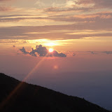
| View to north of Stratton and Bromley from Glastonbury Mt. |
Over the last week, I have seen many AT thru-hikers heading south, or so called SOBO's. These folks start their journey on Katahdin in May or June, and head south to finish in Georgia, starting on the hardest and most beautiful part of the AT. Before they have their hiking legs under them, it must be difficult to fully appreciate the mountains around them. At a shelter two days ago, this seemed borne out when two hikers told me how rough and terrible their time in Maine and New Hampshire was, but that they were greatly enjoying Vermont. The last time I did this with Sean in 2007, only 200 or so SOBO's started. This year, the numbers are not certain, but are likely in the range of 500. One SOBO told me that he was informed by a Baxter Ranger that he checked out 100 SOBOs who left in a single day. Again this just points out the tremendous growth of the thru-hike fascination. In 2007, 1000 hikers started north from Springer; this year the estimates are around 5000. What I have seen in Vermont is a sudden over-crowding issue at the camping sites. There are now many competing groups. We have the AT hikers, the NOBOs meeting the SOBOs. The first 104 miles of the AT is also the Long Trail of Vermont, separating at Maine Junction near Rutland, the Long Trail continuing north to the 'Journey's End' on the Canadian border, and the AT continuing to Norwich Vermont to enter New Hampshire via Hanover over the Ledyard Bridge. The Long Trail also has it's share of thru-hikers, usually heading north, section hikers, and weekend hikers. The end result is that one needs to arrive in a campsite by 5 PM or risk the left-over rocky ground to pitch a tent, and no room in the lean-to.
As I left Kent, I thought for a minute that Wilson had abandoned the mission, and flown the coop. Sunday morning, I ran back to the PO to see if I had left him there while unpacking my 'bump box', only to find the doors locked. Luckily, sports fans, a day later I realized that he had been tossed deep into the pack for safe keeping, and he was later able to join me at photo opportunities at border crossings, etc. It gave me a scare, but all is well.
I spent one more day in Connecticut, most memorably following the Housatonic River. The river is beautiful, but marred by signs warning fishermen not to eat any fish caught there as they are still likely contaminated by PCB's dumped there by GE in the 60's and early 70's. I negotiated a few more ridges, some of which were easy, others difficult. Just before the exit in Massachusetts, we climbed over Bear Mountain, the highest point in Connecticut at 2316'. There in 1886, a monument of a rock pile was erected with an engraved stone to commemorate this.
Two days after leaving Kent I slept in Massachusetts after a somewhat rough day. The rain had been on and off leaving the rocks and the trail very slippery. The descent of Bear Mountain was absolutely treacherous. I arrived in the campsite exhausted, and hungry. As I set up the tent, it began to rain again. After throwing all my gear into the tent, I sat outside to cook dinner, only to drop the foil packet and lost half of the contents on the ground. Perhaps I may have salvaged a bit more than I should have, but forest duff only absorbs the flavors around it and provides excellent roughage. Hunger will drive us to do things we might not otherwise do!
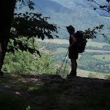
The next day the sun was out, though it was initially very humid as we were greeted in Mass. with two rough climbs up Race Mountain, and Mt. Everett, the second highest peak in Mass. As the day went on, the humidity cleared, and from the second peak, we clearly saw the outline of Mt. Greylock, the first real mountain, and elevation above 3000' since we left Shenandoahs. I was home in New England with the familiar surroundings and mountains!
 |
| Greylock in the distance |
My third day in Mass, I made a point of making Upper Goose Pond my destination. The pond is undeveloped and pristine, now part of a state park. AMC runs the cabin as a free hostel and offers breakfast for hikers, requesting only donations for the service. The pond was wonderful, and the swimming magnificent, and worth the 6AM start on the trail to get there. That night, between the 16 people in the bunks in the cabin and tenters, a record 52 hikers stayed at the facility. The caretakers were a lovely couple also from Williamsville, Vt, and know my hosts here well. It is a small world.
 |
| Upper Goose Pond |
From there I had a couple of short days staying with a college buddy of mine who sang with me in the Dartmouth Aires, an acapella group. Brian lives in his home town of Pittsfield. There he practices law but is better known for his singing and theatrics. I stayed two nights there and 'slack-packed' the trail from Washington Mountain Road to Dalton, Mass.

Nine years ago, I stayed in Dalton with a trail angel, Tom. The trail runs down the sidewalk in front of his house. For years, he has taken thru-hikers in and cooked them dinner, and has charged nothing. I stopped in again and found him home. After explaining who I was and my connection from 2007, I thanked him once agin for his kindness and wonderful service to the hiking community. He told me though that he had to take his name off the ATC list, as the last couple years had brought him hikers from the party element, who carried on, drank, and disturbed his neighbors. I noted with him that this indeed was a dramatic change I had seen in some of the hikers now when I compared things now to the experience in 2007.
Brian put me on the trail in Dalton the next day with the intent of reaching the summit of Greylock and the Bascom Lodge. My digestive tract however, had other ideas, and demanded frequent off trail views. By the time I reached Cheshire, I was nauseous and felt dehydrated. To make matters worse, the church hostel in the town had just closed for 2 days of renovations. After pondering the universe a while, I called my wonderful daughter Meghan who lived 40 miles away in Greenfield. She came to the rescue. The plague seemed to be a 24 hr thing, but I stayed the next day for insurance (also to avoid getting wet as it rained with a vengeance all day long!) As the original plan had included hiking down Greylock with my nephew Mesfin, we instead got together with he and my sister-in-law and went to the new Star Trek movie, then to a Mexican restaurant. This proved far superior to getting wet in the rain.
Meghan dropped me back in Cheshire the next day for the long climb up Greylock. I arrived on the foggy summit in the rain. The lodge was nice and the dinner fantastic. Unfortunately, the bunk room was full, and I spent the hot night feeling like a sardine in the small room with 16 other people, only one of which was a thru-hiker. Most of the others had arrived by car.
 |
| Bascom Lodge |
The next day once again started on a wet note, but improved as the day went on. Water seemed to be cascading down the mountain and trails as I left, and it took me almost 3 hours to cover 6.2 miles. Things dried up a bit by the time I reached North Adams. From there, it was a short 4.2 mile climb (up) to the Vermont border and my next state.
Vermont has been great, though the trail has had significant mud to negotiate. With the higher elevations, I have seen the familiar tree changes, lacking in the south. There is now a clear change to sub-alpine firs and balsams. It's nice to hike again through the whispering pines!
The hope is with a return to trail tomorrow and 120 miles in Vermont to go, that I'll cross the Connecticut River in 7-8 days. From there, I hope to finish New Hampshire by the end of August, leaving me the month of September to enjoy my home state of Maine!