Growing up in New Hampshire, the Appalachian Trail and the White Mountains were in my backyard, and I often spent weekends hiking there with my Dad or my Boy Scout Troop. My involvement in the Outing Club began during my undergraduate years at Dartmouth, and it was while a student from 1974-1978 that my desire to hike the entire AT was born. Thru hiking had just started to capture the imagination of hikers, and only a few each year completed the 2175 miles. It would be another thirty years before I was finally able to walk that long path myself.
Life had other plans for my immediate future, which precluded following this dream: medical school, marriage, medical residency in Colorado and at Dartmouth-Hitchcock, and raising a family. For fifteen years I had hinted to my partners in our Gastroenterology practice that I wanted to take a sabbatical. Adventurers themselves, they were willing to let me go. And it didn’t take much arm-twisting to convince my oldest son, Sean, age 24, to come along. He had just graduated from Middlebury College that February, had no job or immediate plans for one, so the timing was right for us both. In addition, my father (Paul J. Lena ‘50, DMS ‘51) had died in January, and now he would accompany us, some of his ashes resting in a small Nalgene bottle in my pack.
Our adventure began on “Step it Up Day,” April 14th, on the top of Springer Mountain, Georgia. We were greeted by a blinding snowstorm, inappropriately clad in shorts. As a result, our trail names were bestowed upon us by other hikers, and we became “Maine-iacs Uno and Dewey” for the next four months. Friends and family were able to follow our travels on our web blog, to which we would post pictures and weekly updates from internet cafés or libraries in towns. Occasional phone calls kept family up to date on our whereabouts and kept us informed of life in the real world.
We often stayed at shelters. These provided quite a social experience, where we found instant community and in depth discussions, which usually revolved around food. Most days we finished an exhausting 20 miles, barely able to cook our Lipton Rice dinner before falling into a hiking-induced ten-hour coma. Occasionally, “trail angels” provided a barbecue on a mountain bald, or left Whoopie Pies at road crossings or cold Cokes in a stream for us to find. Once a week we would hitch into a nearby town to eat greasy hamburgers or “Hiker’s Special” breakfasts. We became connoisseurs of diners. And along the way, Sean and I reconnected with old friends from North Carolina to Maine, many of whom treated us to “more than one pot” meals, cold beer, and sublime hot showers.
There was time to think, during those long miles in the “green tunnel,” to reacquaint myself with that Dartmouth student of 30 years ago who dreamed of a 2000 mile adventure. The daily challenges of sore feet, aching muscles, hunger, cold, and boredom served to intensify the joys. I experienced exquisite views, had mountaintop wild ponies eating from my hand, walked through a blooming rhododendron forest, and swam in clear waterfalls. Re-climbing the familiar White Mountains of my youth in the company of my son and my father’s spirit made this journey the long awaited fulfillment of a dream.
On September 6, 2007 our 2174 mile hike came to a successful completion on the summit of Mt. Katahdin, an old friend often climbed at home in Maine. After 144 days, 8 pairs of shoes, and 288 Snickers bars, we were home.
Saturday, December 15, 2007
Friday, September 7, 2007
Sweet Success
 The last white blaze

still light on his feet
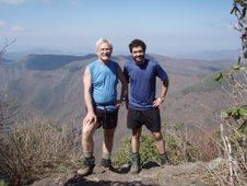
The Maineiacs Uno and Dewey completed their 2174 mile Appalachian Trail adventure September 6, 2007 with the ascent of Mt. Katahdin.Uncle Jay (trail name Stick) drove from New Hampshire to hike this last segment with them and to share our final moment of sweet success.
The last 10 days were nearly perfect with respect to weather and hiking conditions. The air was crisp and clear, more fall-like, but perfect for cruise hiking. Dewey's leg injury improved daily, but never seemed to slow him down enough to allow Uno to stay abreast. Coming into Monson, we did experience a brief but violent thunderstorm. Within just a few minutes, the storm came up from nowhere, with lightning and a microburst of high winds, bringing down tree branches above our heads. We quickly pushed on and were quite drenched by the storm, but otherwise unscathed. We pushed into Monson, staying at Shaw's House; a wonderful hiker hostel with an all-you-can-eat breakfast. They seem to be well acquainted with a thru-hiker's appetite, but were astounded that neither of us asked for seconds. (It's possible that this may have raised issues of authenticity as thru-hikers!)The hike through the hundred mile wilderness came off flawlessly. The weather was perfect, (if not a little chilly for the likes of Dewey). We went into the wilderness with one day's worth of food then met Kathy and Tracey at Gulf Hagas for lunch, a swim in Screw Auger Falls, and to pick up our supplies for the next four days. The first 40 miles is mountainous and is difficult at times. We had a wonderful campsite the first night at Cloud Pond on Barren Mountain, but the 19 miles that day took us til 7:30pm to complete. Then came the slow, arduous, muddy walk over the Chairback range which has a reputation with thru-hikers as the toughest in Maine; only surpassed by the Mahoosucs. After Gulf Hagas, we scaled the last true mountain before Katahdin: Whitecap at 3800' is one of New England's hundred highest peaks. With these mountains behind us, the terrain became much more level, and somewhat easier to cruise through lake country.
Our final day on the trail, we hiked the last three miles to Abol bridge, then 10 miles into Daicey Pond, where Kathy had rented us a cabin for the night. We had the afternoon to relax in the sun, and admire once again the stunning views of Katahdin across the lake. Uncle Jay spent that day hiking the Owl, but joined us that afternoon at the campground.
The final day to summit Katahdin offered us nearly perfect weather conditions. After a somewhat leisurely breakfast of huevos rancheros, we began hiking the Hunt trail from Katahdin Stream at 9am. We were truly energized and nearly ran up the mountain, reaching the summit just before 11:30. We noticed a man taking pictures of us and initially thought the Bangor Daily News was there to cover our finish. But no, it was Uno's partner 'gastro Dan', who had driven up that morning to climb the mountain and greet us with whoopie pies, and hearty congratulations. Not knowing our expected departure time, he had been on the summit since 9:30, a truly heroic effort.
The down-climb was uneventful, as we avoided any rain even though the clouds appeared. There was champagne and celebration at the bottom. Thus ends our saga and adventure on the AT for now. Neither of us was tempted to do a 'yoyo', turning around immediately and hiking to Springer, as some hikers (usually those who have no life) have been known to do in the past. One trip on the AT which was the adventure of a lifetime seems sufficient for now. We both expect to become couch potatoes for the next week, and Kathy has made it her personal crusade to restore at least part of the 37 pounds Uno lost during this excursion. We cannot thank our friends and family enough, especially Kathy, for their help and support, without which the trip would not have been possible!
Monday, September 3, 2007
The End is Near
 Screw Auger Falls
 Tracey, Sean, Mark, Kathy at Pleasant River crossing
 And they're off...again
 Sean is grateful to survive his death defying leap. See first picture above for scale.
 What a choice...Moxie or Coke? and note Whoopie Pie in other hand
 Which way do we go? And do I have to go back to work
on Monday if I turn around and go South?
Tuesday, August 28, 2007


Monday, August 27, 2007
Maineiacs spend two unscheduled days in Orono
Uno and Dewey expect to resume the trail tomorrow to complete the remaining 170 miles of the AT to Mt. Katahdin, after making and unexpected two day recovery back in the comfort of home, after Dewey tried to perform do it yourself leg surgery with a dull rock on the summit of Mt. Avery. Up to this point, due the difficulty of the frustrating terrain,and wet humid slippery conditions, Dewey had been cursing Myron Avery in fact for ever having pushed the trail through to Maine in the first place. He apparently got his answer.
The home state has continued to be a challenge for the thru-hikers. In the last three days before reaching Sugarloaf, we did three 10 mile days; but each day included scaling at least two four thousand foot peaks, not a trivial endeavor. Of the twelve 4,000 ft peaks in Maine, the trail manages to climb all but four in the western part of the state. With the completion of West and Avery peaks, we won't see that elevation again until Baxter. We spent one night in the summit lodge on Sugarloaf, easily accessed by a half mile spur trail off the AT. The building is left open especially for thru-hikers to use as a shelter. We thought we had the place to ourselves until 7:30pm, when 6 college students arrived in a pick-up truck, having driven up the cat access road, loaded with plenty of party materials and a tent which they proceeded to set up in the building. They were actually quite nice and offered us a beer, at least recognizing that the way to a thru-hiker's heart is through his stomach and love of beer.
The following day we descended Sugarloaf in a 20mph winds with rain and fog, only to climb the other side of the Caribou Valley over the Crocker Mountains. These have wooded summits, no views and add at least 3 miles to the trail before reaching route 27. Reaching the road finally at least we were rewarded by meeting Kathy and staying the night at a condo owned again by our good friends the Boleys (of Lancaster PA fame.) After showers and shopping in the lovely metropolis of Stratton, we enjoyed a nice repast at Hugs Italian Restaurant that evening.
The next day we had a slow start, lacking in general motivation , but managed to get ourselves on the trail by 11am. It was warm but very humid as we set out to complete 15 miles to Little Bigelow shelter over the Horn Peaks, West Peak and Avery. Because of the humidity and a brief shower the rocks remained extremely slippery and at times it felt like walking on ice. These were the conditions which set Dewey up 'for the fall' on the summit of Avery, gashing his lower leg. Despite the injury he got up and was able to complete the 7 miles to the shelter, but in the process the front half of his calf swelled to twice it's size, making walking a challenge. We finally managed to get into the shelter, literally minutes ahead of a deluge and lightning storm that had been threatening us for two hours while we walked along the ridge. We called the nurse-pit crew who returned the following morning and picked us up near Flagstaff Lake.
At this point we have passed the 2000 mile mark and have seen Katahdin from the summit of Saddleback Junior. With any luck, we expect to summit Thursday or Friday next week after Labor Day, weather permitting. We'll have more updates if there is any internet access in Monson. Otherwise the final chapter will be written after we complete the hike next week.
Sunday, August 19, 2007
Maineiacs home in Maine
Dewy and I continue our trek to Katahdin, with approximately 245 miles to go and continuing. We are spending the second of two nights at The Andover Guest House in Andover, Maine, which has been a great hostel for us to stop and rest. Today, with full packs, we hiked 10 miles from the Andover 'B' road to South Arm Road, with the intent of spending two nights here. I'm trying to get over a cold with bronchitis, and camping in the recent 30' temps seemed counter-productive. Tomorrow we'll be off on the next 47 mile segment of the trip which will bring us to Sugarloaf by Friday.
The last few days of hiking can be classified as arduous and cold. As we spent time here hiking 10 years ago with Troop 478, we are hiking in familiar territory. The Mahoosucs (Ma-who-SUCKS; native translation emphasizes the last syllable!) are universally regarded by all thru-hikers as the toughest section of the AT. These mountains are extremely rugged and difficult to hike due to the rocky nature of the terrain and the vertical feet of elevation lost and gains. Dewey mentioned the Presidential range requires 10,000 vertical feet climbed, but one will climb over 8,000 vertical feet in the 30 mile section of the Mahoosucs. The first day after Gorham was somewhat easy and we covered 12 miles in half a day. The second day however, it took us 11 hours to cover 15 miles, with the toughest section being the Mahoosuc Notch, a one mile section of giant boulder strewn trail that took an hour and a half itself to negotiate. We found the dead moose that we had been hearing about for the past two weeks. It had stumbled into the notch in early July, and had broken one of its legs. It was suffering terribly til someone put it out of it's misery. One had to negotiate over the corpse and the ungodly stench that still permeated the area. One of the nick-names for the notch is ice gulch, as even in August, one can find ice under rocks. As you walk through the gulch, certain low pockets will drop 10' in temperature. Our unlucky moose found it's final resting place in one of these pockets, which has delayed the natural degradation processes and has allowed more hikers to see and experience the thrill. However at the end of the day, it was nice to have the extra protein in the pot that night!
We expect the hiking to improve significantly over the next few miles, and longer distances should be possible. We plan to meet Kathy at Sugarloaf this Friday then continue on our way.
Wednesday, August 15, 2007
White Mountain Magic
Hello everyone, Today is an important day for the Maineiacs for two reasons. First, today marks our fourth month on the trail; second, we only have 300 miles left to go! We arrived in Gorham, NH today at noon, marking the end of our time in New Hampshire. All that is left to do are the final few hundred miles in Maine. We have come a long way and I, for one, am tired and looking forward to seeing that sign on Baxter peak that marks the end of our journey.
If the Appalachian Mountains were a middle school, the White Mountains would be the malicious school bullies who take pleasure in giving swirlies and beating up other kids for their lunch money. Indeed, the Whites play by their own rules and are unlike anything else on the Appalachian Trail. The Trail consistently rises above five thousand feet above sea level and at Mt. Washington breaks six thousand feet. The amount of vertical feet lost and gained in the presidential range is staggering: hikers gain and lose 10,000 vertical feet in a twenty five mile section. As a result we scaled back our mileage to 10-12 miles a day from our usual twenty.
The White Mountains receives the most visitors of any park or national forest in the United States due to its proximity to Boston and New York. As a result there are strict regulations on backcountry travel. These restrictions throw a real wrench in the works for most thru-hikers because we have to plan around the crowds and the huts. The AMC huts are a series of alpine bunk houses that cater to weekenders who dislike the whole "camping" aspect of backpacking. For eighty dollars a night the hut crews will cook your meals and give you a soft bunk to sleep in. They are pretty posh accommodations for the backcountry.
The AMC allows thru hikers to stay at the huts in return for a few chores. Unfortunately, only a couple of thru hikers are allowed each night, so if you don't get to the huts early enough you might find yourself sleeping on the side of a mountain. Usually the huts are not a problem and depending upon the crew, most will allow a few extra thru hikers in each night. I felt, however, that as a thru hiker I was a second class citizen: someone whose presence is tolerated but rarely liked. It is an interesting feeling coming into the Whites as a thru hiker. It is the first place in the last 1700 miles where we've had to pay eight dollars a head to camp at designated campsites. (It certainly gives credence to the claim that the AMC really stands for "Appalachian Money Club.")
Each morning in the Whites, we awoke to the sounds of dishes rattling and the smells of pancakes cooking and coffee percolating on the stove. We would pack up and wait for the paying customers to eat before we were invited back to the kitchen for breakfast. After breakfast, the crews put us to work sweeping, washing dishes, and tidying up the bunk house.
Despite the added hassle of the huts, we had a fantastic time in the Whites. The weather was perfect; clear, sunny and cool. We had extraordinary views that stretched into Maine, Vermont and New Hampshire.When we reached Crawford Notch, my friends Scott Guenther and Jono Newton joined us for a section of the trail. We hiked from Crawford Notch to Mizpah hut and the next day we summited Washington together. Although there wasn't much of a view up top, we had a good time together and I was very happy for their company.
The last hut in the presidential range was our most remarkable and interesting experience in the huts. We arrived late after a long day that took us from Mizpah Hut in the south over Mt. Washington to Madison Hut on the northern edge of the Presidentials. A few people were milling around outside when we arrived, and among them were a crowd of ten year old girls. At one point, they got up and walked past us toward the hut. When they were right next to us, I heard one of these little girls say, "Ewww, gross" and then proceeded to hold her nose and breath. Just what you want to hear after a long day of hiking. I didn't think that I smelled that bad...Oh, well. C'est la vie.
Monday, August 13, 2007

Thursday, August 2, 2007
Maineiacs cross through Vermont, but New Hampshire looms ahead
Uno and Dewey continue their trek northward, today crossing the Connecticut River into Hanover, New Hampshire; crossing off yet another state, with only two left to go. (But over 400 miles!) Vermont was a great state for the AT, and it was wonderful to be home at last. After spending a zero day with our friends the Shafers' in Williamsville, we resumed the trail in Danby.
The weather dried out and so did the trail, as the mud puddles became smaller and less threatening. The climb up Killington felt like climbing a real mountain again. We had a perfectly clear day with great views into Vermont and New Hampshire. We found it especially rewarding, as we found the summit snack bar open on top... so much for powdered hummus. The prospect of cheeseburgers, french fries, and ice cream bars proved too alluring for us. We continued the hike to Sherburne Pass, and stayed the night at the Inn on the Long Trail. This spot is legendary with the thru-hiking crowd, and offered comfortable accommodations as well as great food and a bar. The place was built in 1939 as one of Vermont's first ski lodges.
Departing back on the trail from there we quickly reached 'Maine Junction', the true juncture of the Long Trail, which continues north to the Canadian border, and the AT which turns east to Hanover. So, here one has to decide if they want to go to Maine, or Canada; not much of a choice in my opinion as Maine wins hands down! We had no further sojourns into civilization for the rest of the hike through Vermont, spending the next three nights on the trail. Going east-west, we crossed many ridges with a lot of climb, but found the trail easier than in the Green Mountains. We did a little swimming in the White River as we crossed yesterday in West Hartford.
Today we take a bus southward to Concord to visit family for two days, then resume the trail on Saturday with Uncle Jay, who's not a Maine-iac at all... We'll have to solve that problem later. Let's hope for continued good weather through the Whites. More updates to come.
Sunday, July 29, 2007
Maineiacs in Vermont
We continue our journey north and are now more than half way through Vermont. So far it has been quite wet and has apparently been so for the last several weeks, despite our rather dry and dessicated experience in nearby New York. Saturday, and part of Sunday, however, we are out of the rain on a 'zero' day spending time with our friends
Deb and Tim Shafer in Williamsville Vt.
Our hike up Greylock was quite spectacular. The weather was perfect with low humidity and outstanding views, especially north to Vermont. An extra bonus from our stand point was the lack of tourists on the summit. Normally there are two roads up to the top, but these are undergoing major renovation through 2008 and are closed to traffic. Consequently, the only people on the summit were those who walked there. We did see at least 20 or 30 day-hikers, but the lack of traffic and smog was not missed.
The next day we hiked the remaining 7 miles in Mass. to cross the Vermont border, but could not pass up the opportunity for a mid-morning second breakfast at Friendly's in North Adams, as it was only a half mile off the trail.
Once we entered Vermont we were greeted with wet and very muddy conditions. I think hopscotch would best describe our hiking technique over the past several days, as we desperately tried (unsuccessfully) to keep our boots from disappearing in the muddy
quagmire (and us with them.) The trade off is the obvious change to a New England landscape which is a welcome change for us.
We are now climbing real mountains, walking through wonderful pine forests and are enjoying fully the sense of being home in a familiar environment.
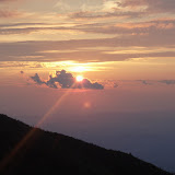
We camped on the summit of Bromley Mountain, a popular ski area in Southern Vermont. We set up camp on the landing stage for the superquad chairlift. There we fully enjoyed the views of the surrounding mountains, the sunset (see picture), and the stars and moon as they appeared that night. We were rudely awakened at 3:30 am by another rain shower and had to beat a hasty retreat into the warming hut which is left open for hikers.
We are finding and camping at more mountain ponds. A swim at the end of a long day is incredibly refreshing ( and maybe cuts the odor a little bit).
We were surprised the other day by a visit from another college friend of mine, Al Henning, who like Brian Litscher sang with me in the Dartmouth Aires. Al was flying back to Hanover from California and spoke to me while he was awaiting a connecting flight in Atlanta. I told him of our location on Bromley Mountain and our expected
itinerary for the next day. After finally arriving in Hanover at 3am, he must have started driving at 6am and found a road that intersected our trail then started hiking south to meet us. It was a surprise and a great treat to talk and catch up on old times as we hiked back to his car. This was Dartmouth dedication above and beyond!
We are back on the trail today and expect to tackle Killington and Pico Peak tomorrow, the first time above 4000 feet elevation since North Peak of the Three Ridges in Virginia. Once we reach Route 4, it's up to Middlebury by bus for a day so Dewey can visit a few friends at the language school. We hope to finish Vermont and roll into Hanover by Friday. More updates to come.
Deb and Tim Shafer in Williamsville Vt.
Our hike up Greylock was quite spectacular. The weather was perfect with low humidity and outstanding views, especially north to Vermont. An extra bonus from our stand point was the lack of tourists on the summit. Normally there are two roads up to the top, but these are undergoing major renovation through 2008 and are closed to traffic. Consequently, the only people on the summit were those who walked there. We did see at least 20 or 30 day-hikers, but the lack of traffic and smog was not missed.
The next day we hiked the remaining 7 miles in Mass. to cross the Vermont border, but could not pass up the opportunity for a mid-morning second breakfast at Friendly's in North Adams, as it was only a half mile off the trail.
Once we entered Vermont we were greeted with wet and very muddy conditions. I think hopscotch would best describe our hiking technique over the past several days, as we desperately tried (unsuccessfully) to keep our boots from disappearing in the muddy
quagmire (and us with them.) The trade off is the obvious change to a New England landscape which is a welcome change for us.
We are now climbing real mountains, walking through wonderful pine forests and are enjoying fully the sense of being home in a familiar environment.
We camped on the summit of Bromley Mountain, a popular ski area in Southern Vermont. We set up camp on the landing stage for the superquad chairlift. There we fully enjoyed the views of the surrounding mountains, the sunset (see picture), and the stars and moon as they appeared that night. We were rudely awakened at 3:30 am by another rain shower and had to beat a hasty retreat into the warming hut which is left open for hikers.
We are finding and camping at more mountain ponds. A swim at the end of a long day is incredibly refreshing ( and maybe cuts the odor a little bit).
We were surprised the other day by a visit from another college friend of mine, Al Henning, who like Brian Litscher sang with me in the Dartmouth Aires. Al was flying back to Hanover from California and spoke to me while he was awaiting a connecting flight in Atlanta. I told him of our location on Bromley Mountain and our expected
itinerary for the next day. After finally arriving in Hanover at 3am, he must have started driving at 6am and found a road that intersected our trail then started hiking south to meet us. It was a surprise and a great treat to talk and catch up on old times as we hiked back to his car. This was Dartmouth dedication above and beyond!
We are back on the trail today and expect to tackle Killington and Pico Peak tomorrow, the first time above 4000 feet elevation since North Peak of the Three Ridges in Virginia. Once we reach Route 4, it's up to Middlebury by bus for a day so Dewey can visit a few friends at the language school. We hope to finish Vermont and roll into Hanover by Friday. More updates to come.


Saturday, July 21, 2007
Dalton Mass.,Vermont looms ahead in 24 miles
Sean posted his update this morning but I thought I would add my own two cents to the blog. It has been quite a while since we have been afforded internet access, and we apologize for the lack of news over the past several days. Tomorrow we expect to tackle Mt. Greylock, the highest mountain and point of the AT in Mass. We spent last night with my college friend and fellow Aires singer Brian Litscher, and his wife Marie. They rejuvenated us with steaks on the grill, Ben and Jerry's ice cream and a soak in the hot tub. We took our time getting out today, while shopping for groceries and finding Dewey a new pair of trail runners (his last pair had 750 miles on them!). We got on the trail and hiked 10 miles to Dalton (big day, right?) and are holed up tonight with Tom, who offers his house to thru-hikers as a place of respite, providing beds and meals. He has been doing this for twenty-five years, and accepts no donations or fees! We have had it good for the past two nights and its going to be hard to get used to 'roughing it' again on the trail. However, we expect to camp tomorrow on the shoulder of Greylock, and to be in Bennington by Monday evening. We'll continue the hike north through Vermont, and will get picked up by our friends Tim and Deb Shafer, by the end of the week; themselves returning from a four day backpacking trip on the northern Long Trail. Ah, it's great to be back in New England where we have friends and family. We had a wonderful dinner with my sister-in-law Patti in Great Barrington, enjoying stone fired pizza that was out of this world. We had originally planned to return to the trail that evening after dinner, but ended up opting for a motel instead as post-prandial lethargy took hold. This turned out to be a very wise decision, as it rained cats and dogs within 15 minutes of our check-in.
New Jersey and New York passed relatively quickly. NJ was pleasant with fairly gentle terrain. New York posed very significant challenges at times, with sharp rocky climbs and scrambles. Of course we hit this in the middle of the heat wave that Dewey described. After crossing into New York, we spent the next 6 miles on open rock ridges, which just concentrated the heat even more. Far below us was wonderful- looking Greenwood Lake. We reached the road, nearly dying of heat exhaustion, but were successfully resuscitated by a nearby creamery that had the best ice cream, or so it seemed at the time. It was then that we decided to pull an emergency motel stop on the lake with the Antons, who were very lovely people. We called and they gladly came to pick us up (and later gave us a ride back to the trail the next day) and brought us to the motel. A swim in the lake fully restored us. That evening we mt Debbie Holton-Smith, a friend from our Dartmouth-Hitchcock days who met us and took us out to dinner. It was great to catch up after so many years. The following day was the worst of the heat, registering at 98 degrees locally holding our mileage down to 14 miles that day, the shortest mileage day since we started the AT. Luckily we found a trail angel- Patty-o -just after entering Harriman State Park. He provided food cooked on a small grill and cold beverages. He also suggested we camp at Island Pond, only 1.5 miles up the trail from there. This was the best advice, as the lake was wonderful for swimming and we camped on a grassy knoll with a wonderful view.
The last day of the heat wave was not as brutal so far as the temperatures were concerned, but the humidity could be cut with a knife. We found ourselves being chased off Bear Mountain by a severe thunderstorm, which necessitated yet another unscheduled motel night in Fort Montgomery.
It was about this time that it seemed to dawn on us that maybe we could just simply plan on staying at motels every night, and forget all this camping stuff! In the meantime, we had also discovered that every day at noon we seemed to cross a road which inevitably had a deli within a half mile. We took it on ourselves to sample every deli, for the good of trail. Thus between the motels and the delis, who needs to carry food? Dewey was particularly enthusiastic about the delis; prompting our theme song:
back to back
deli to deli
well I don't give a damn
about PB and jelly
back to back
deli to deli
it was pastrami jamboree
With any luck we should be to the New Hampshire line in 12 to 14 days, covering the 150 miles that Vermont has to offer. We may slow down a bit, now that we are in the interesting part of the AT. More updates to come!
Friday, July 20, 2007
The New England Home Stretch
After three months of hiking, I have exciting news.
WE HAVE CROSSED INTO NEW ENGLAND!!
In the time since our last update in Vernon, NJ, we have breezed through New York, Connecticut, and are now in Pittsfield, Massachusetts, where one of my dad's college buddies is feeding us steak and giving us a dry place to sleep for the night. It helps that the further north we go, the more people we know. We met up with a number of people between New Jersey and Massachusetts. In Warwick, NY we went out to dinner with one of my mom's best friends named Debbie who I haven't seen since I was in diapers. And two days ago in Great Barrington, MA my aunt Patti picked us up at the trail head and shuttled us around town and bought us pizza. Although this past stretch of trail was not particularly challenging terrain-wise, the weather nearly killed us. We faced a brutal heat wave with temps that reached into the upper nineties. Then, as if the heat wasn't bad enough, mother nature opened the heavens on us for two days straight. It was frustrating at times, but we pushed through. The fact that we are rapidly closing the gap between here and Katahdin is a huge psychological help.
The past week or so, for whatever reason, we have managed to stay with the same group of hikers instead of blowing past them like we normally do. It has been really nice because allows us at least some social interaction when we stop for the night. Our group includes: Bonafide, a middle aged woman from Florida who hikes with an overprotective Portuguese Water dog named "Bone." Little Red and Wolf hail from Durham, North Carolina. Little Red gets her name from her red hair which you can pick out from a mile away. Wolf, her boyfriend worked for an environmental consulting firm in Durham, and before that had spent ten months as a soldier in Iraq.
We have also had the pleasure of hiking with Ziplock and Nitro, a young couple originally from Nashville Tennessee. Nitro wears her hair in braids while Ziplock sports a bushy brown beard that sticks out form the sides of his face, and a blue bandanna around his head. He is affable, with a great sense of humor and a quick smile, and has a remarkable gift for telling stories. Every night, after stoves are put away and the rays of the sun start to disappear behind the canopy of the trees, he produces a small backpacker's guitar and sits and sings Grateful Dead tunes in a soft tenor, as if trying to coax us all to sleep.
Finally, there's Steven. We have been hiking with Steven since we first ran into him in Duncannon, Pennsylvania. He is an odd sight for sure, as he wears a hiking kilt, a button down collared T-shirt, and sports a mohawk dyed electric yellow. Once you get past his odd appearance, he is very nice. He refuses to take a trail name for some odd reason, and now has about ten different ones following him up the trail, and gets a new one every time he goes into town. We were present on one such occasion, when at a bar an inebriated older gentleman staggered up to Steven and slurred, "You look like...an...Electric Lizard." Despite our best efforts, we could not get the name to stick.
Anyway, Steven is a wonderful fellow, originally from Kentucky who is easy going and fun to hang out with. We didn't really get to know Steven until New York, after a particularly brutal heat wave that threatened to kill everyone on the trail forced the three of us to retreat to an air conditioned motel called Anton's on the Lake. There we took a swim and tried to recover from our collective heat exhaustion. Two days after we got back on the trail, my dad received a frantic call from the motel's owners. They were livid because Steven had apparently left without paying his bill and wanted us to say something to him. When we approached him about it, Steven exclaimed, "What do they mean I didn't pay? I couldn't find them that morning so I just left seventy five dollars in cash in the maid's tip envelope!" I believe the whole mess was sorted out in the end.
Tuesday, July 10, 2007
Pictures from PA visit 6/29-7/2
 Kathy and Tim Boley's Lancaster B&B
Route 309, near New Tripoli PA

Back on the trail

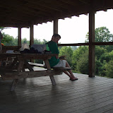
Sean catches up on the latest news

Mark edits the blog

Rest and relaxation

Sean gives up the i-pod for NPR

Mark needs more calories!

Sunday, July 8, 2007
Update: July 8th, Vernon, N.J.
Just a brief update as we are about to leave New Jersey behind us; to let you all know that Dewey and I are still alive and continuing on our northern trek. Since our last update, we completed Pennsylvania with little further ado. The weather was kind to us with sunny dry, low humidity days. Fortunately, the reports that the rocks got even worse during the last 50 miles after Lehigh Gap proved totally exaggerated, as many reports of this type tend to be. The climb out of Lehigh Gap was awesome and wonderful, over large open rocks, with wonderful panoramas. We found it was interesting as we continued along the ridge-top for the first two miles, as it was almost completely devoid of vegetation. We later learned that this was the consequence of a Zinc mine that had been located in the valley below. The ash given off by the processing completely killed all vegetative life, leaving a stark rock-filled landscape, now on the super-fund clean-up list.
We spent two days at Delaware Water Gap, Pa. The second day was an unanticipated 'zero' day for us, as Dewey had a few essays to complete at the library 4 miles away for a job application. We spent the second night at the Episcopalian Hiker Hostel. This was a real treat, as the congregation put on a hiker feed on Thursday nights, more than justifying our second day there.
We entered N. J. the next day by crossing the Delaware River over the I-80 bridge, with all it's highway noise. We appropriately photo documented the event somewhere in the middle. On the other side you enter Wadsworth State Park and enter a beautiful forest, gradually climbing the ridge on the other side. The trail quickly loses the sounds of the highway and hugs cascading waterfalls through beautiful lush green forests. You quickly pass by Sunfish Pond, which is the first glacial pond left by the glaciers. Although it is posted prohibiting swimming, the temptation proved to be too great. The summits of the ridges were different than Pa., offering a lot more open grassy tops with vistas all around. However, our old friends the Pennsylvania rocks seemed to follow us as well, for at least the first two days. New Jersey has been interesting, with varied terrain, fields and forests, and it's occasional delis at the road crossings. Last night we managed to lose a shelter location (although we followed the map location to a tee) and found ourselves camped (perhaps illegally) by the shore of a beautiful lake, where the shelter was supposed to be located. We enjoyed a brief swim and a good dinner. Today the high heat and humidity returned to last for at least the next couple days, but this is summer, after all.
Tomorrow, within 10 miles, we will leave N. J. behind us for the 90+ miles in New York that remain, before we find ourselves home in New England. There we will finally have much family and friend support as we continue our march to Maine. More updates to come!
Tuesday, July 3, 2007
Kathy Finds the Mountain Men
After 11 weeks of the single life, I got tired of talking to the dog and decided to make a pilgrimage to the AT to find the mountain men, and to provide some trail magic. (Sean's requests were for: 1. The NY Times, 2. Economist magazine, 3. several books, and 4. last, but not least, chocolate chip cookies. These requests were granted, with the addition of clean clothes for "city life" so I would not be embarassed to be seen with them in public!)
So, after winding my way from Maine to Massachusetts to New Jersey, I ended up in New Tripoli, PA on Route 309, waiting for Mark and Sean to arrive. They were standing in the parking lot of a hotel-restaurant, and were a sight for sore eyes. They were a blast to the noses as well, as they were quite pungent, to put it mildly! We all piled into the car, and headed for Lancaster, PA, for some well earned R&R at the Boley's. Great food, showers, laundry, and conversation occurred over the weekend, as well as a trip the the local theater for a performance by Bill Cosby. As Sean has described, Mark was the skinniest I have ever seen him. I did not complain once about the amount of food he was eating; actually I was encouraging him to eat more! That is a first :)
He also had a fever, so my nursing skills were put to use, and gradually he improved over the weekend. Grocery shopping ensued, with the addition of some Indian food in a box that looked like good easy trail food. A change for the tast buds seemed appropriate. Tim Boley also donated some MRE's (Army issued meals ready to eat,) which Mark and Sean reported to be very good in their phone call last night. Kathy and I delivered them back to the AT on Monday, July 1st, waving and honking the horn as they trudged off into the woods.
Monday, July 2, 2007
Pennsylvania Rocks
Greetings from Lancaster Pennsylvania! Since my last entry we have made it through Maryland and all but fifty miles of Pennsylvania. We expect to be in New England sometime within the next two weeks and we have never been more excited.
Unfortunately, these past few weeks have been the hardest part of the trail so far. Not hard physically, just mentally exhausting. I was warned this would happen in Georgia, by a former thru hiker. She was a middle aged woman from Florida who had hiked the trail with her husband back in the eighties. Her trail name was "Gorilla" because as she put it, "I loved bananas and I didn’t take shit from anyone." Anyway, she told me something that makes more and more sense the farther I hike. She said,"the first thousand miles or so is all physical, the second half is mental" You can see this in the numbers of people who complete the trail. Every year, more than 1,500 people set out from Springer. Of those people, only five to six hundred make it to sign in at Harpers Ferry. Of those that make it, only fifty percent make it to Maine--approximately 200-300 each year.
Now that we have more than 1,200 miles worn into the soles of our shoes, Gorilla’s words make even more sense to me. I understand why so few people make it to Maine and I think it mostly has to do with Pennsylvania. Pennsylvania, for lack of a better word, sucks. Now, I don't really hate all of Pennsylvania (after all, this is the state that gave us the Philly Cheese Steak, the Amish, and provided the inspiration for the Rocky movies) just the mountains. They are really boring, and consist of forests that have been decimated by gypsy moths, long, flat ridges with few, if any, views, and nasty, sharp rocks that leave you sore and frustrated at the end of the day. Pennsylvania has been hard on us and we are glad to be closing in on the border. The only thing that has kept our sanity in tact is that we can feel ourselves getting closer to home. The thought that we will soon be in familiar territory gives us that extra bit of mental stamina we need to put one sore foot ahead of the other and fight this rock-induced mental torpor.
I have also found that I am a different person now than when I started. I don't mean that I have "found myself" or any of that other touchy feely BS but rather, I am physically a different person. My upper body has shrunk, my legs now resemble tree trunks and I have lost nearly fifteen pounds of weight (and I didn't have all that much to lose in the first place) My dad has lost almost twenty pounds. When my mom came down to see us, she scolded him, "you have lost waaay too much weight...you should eat more" My friend Rene, who thru hiked the trail last year informed me that this transformation is a normal part of hiking, but it is different for men and women. Women, she said, finish the trail looking trim and tough. Men, on the other hand finish looking like Tyrannosaurus Rexes.
Birdman:
As I have mentioned several times previously, you really meet some strange characters out on the trail. Take Birdman, a grad student from the University of Maine in Orono (who incidentally lives right down the street from my family), he is a brilliant naturalist who hikes with binoculars around his neck, and listens to the thousands of birdcalls uploaded to his ipod while he hikes. If you see him hiking he'll periodically dive off into the woods for snakes and gets really excited about seeing new wildlife. Two weeks ago, we arrived in Pine Grove Furnace state park the geographic mid-point of the AT. There we found a few of our friends milling around the camp store ravenously eating hamburgers and fries. Suddenly, another thru hiker came over and said, "did you hear what happened to Birdman?" We shook our heads collectively. "He had to go to the hospital for eating poison ivy!" Apparently a friend of his had told him that the Native Americans would regularly eat poison ivy. Unfortunately, his bad decision caused him to break out in a full body blister and had to be rushed to the ER for treatment. Apparently he is planning to get back on the trail.
Challenges of the Trail:
Another little known tradition of the AT are the annual challenges that boredom addled thru hikers invent to amuse themselves. The time honored challenge is one called the four state challenge where hikers camp at the Virginia-West Virginia border and then hike the 46 miles through Virginia, West Virginia, and Maryland and camp in Pennsylvania. They usually start at three in the morning and routinely don't finish until eleven at night. In this same vein, I heard of a group of hikers promoting a new challenge called the “one night in New Jersey” Challenge where you do two consecutive 35 mile days through Jersey. Needless to say, I opted out of this particular challenge.
One challenge that I did participate in, however, was one with a long and distinguished tradition among hikers called the Half Gallon Challenge where hikers time themselves as they attempt to eat an entire half gallon of ice cream in one sitting. The record is three minutes (although he melted the ice cream first and drank it). Eating that much ice cream is an ordeal unto itself. It takes most people over an hour to finish. I sat down and finished the 3360 calories of ice cream in a lightning fast 28 minutes flat. Everyone was astonished…and a bit disgusted.
That’s all for this entry. With any luck my next update will be from New England!
Sunday, July 1, 2007
Lehigh Gap, PA June 30,2007
It's been some time since we've been able to update the blog, as internet access have been somewhat difficult to find. We got into Duncannon on a Sunday, and could only have access to the hotel's computer, for which they charged a nominal fee of $2 for 30 minutes, so needless to say we didn't try to update there. We've now made it to within 13 miles of Lehigh Gap, and it's only 50 miles to the New Jersey border, and two weeks or less of walking til we're home in New England. Currently we are resting two days with friends in Lancaster, Pa. while I get over some kind of viral thing, and regroup for the next part of the journey. Kathy (no trail name), has been making a southern tour visiting friends from her childhood in N. J. and arranged a rendezvous with us on the trail. She brought us to Lancaster where Tim and Kathy Boley, recently relocated from the Bangor area, have graciously hosted us, showing us the highlights of Lancaster Co, and Amish Country. We've taken advantage of being in a home to wash down the backpacks and reconfigure our equipment. With the heat and humidity during the last couple of weeks, both the packs and ouselves were a little ripe. A bath with Mr. Clean and a little bleach and things are good as new (for the packs, not us!) It turns out that Dewey was not sized correctly when he was sold his Osprey pack, and as he lost weight, the pack became more and more uncomfortable. Although we bought the pack at EMS in Boston, the EMS store here would not trade out unless we could show them the the receipt. However they did give us a 20% discount on a new pack, and Dewey figures he can sell the old one on Ebay. So now we have both switched packs on this trip; no wonder the outfitters along the trail seem to do so well.
Pennsylvania has proven to be every bit the challenge that we expected it to be. Apparently the statistics indicate that of the people indicating intentions to complete a thru-hike who reach Harper's Ferry, about 50% are successful in doing so. We also learned that many of the people dropping out this year have done so in Pennsylvania.
The initial half of PA was quite a pleasant surprise. The trail runs through several state parks with beautiful forests and ridges. We stayed in a nice hostel in Pine Furnace Park, set up in a historic building built in the early 1800's rumored to have housed Martha and George Washington for a night. We learned on arriving there however that the house was built 15 to 20 years after George's death. We stayed overnight in Boiling Springs, and took advantage of the local pool with water slides for a great cool down and clean-up. Although there's no place to stay in Hot Springs, one of the two B+B's in town opens it's back yard to hikers who want to tent. There were at least eight tents there the night we stayed. The weather to this point was great with low humidity, excellent for hiking, while we hiked twenty five miles or so across flat farmlands and fields to the Duncannon area.
We arrived as expected in Duncannon, and spent one night at the lovely Doyle Hotel (another story!) The hiking from that point on can only be described as tortuous. The mountains are long flat ridges about 1500 ft high. The amount of climbing is actually minimal, so you would think the hiking would be easy; not so unfortunately. The weather turned much more humid and hot, actually breaking previous records for this part of Pennsylvania. It is amazing how much heat alone can sap your strength. Things (like backpacks) just never seem to dry. You feel damp while trying to sleep at night. No matter how many times you rinse your clothing in the stream, you can't quite shake the eau de mildew that seems to overtake everything.
The second recent challenge has been the Pennsylvania rocks. As we have discovered, many trail legends of what lies ahead have proven to be nothing, or less of a big deal than as billed... up to now. The rocks are every bit as hard as we've heard. These rocks can go on for half a mile at a time, are 8 to 12 inches in size, and usually roll when you step on them, posing significant threat of ankle injury. While rolling on the rocks, you have to also be wary of Timber Rattle Snakes, which are quite common in the area. We came across a warren of seven such snakes the other day sunning on the rocks in the middle of the trail (see attached picture update. If you hear a rattle, while rolling on a rock, you know you might be in trouble. (Note to self; but don't worry, 30% of bites do not inject venom, and there hasn't been a fatal snake bite in PA in over 25 years!) The frequency and length of exposure to this kind of terrain is increasing the farther north we go , and is supposed to become the most challenging beyond Lehigh Gap. The rocks apparently continue for a day and a half in N. J., then finally disappear.
Our third and final challenge in this state has been the lack of interesting topographical features. Most of the time we are walking in the woods, with little view, on largely flat terrain. Of all the states to this point on the AT, Pennsylvania has proven to be the most difficult challenge to hurdle.
Luckily, the weather has cleared and the humidity is gone. The next several days look great. Once we leave Pa., we will rack up the states quickly. We have only 77 miles in N.J., and 90 miles in N.Y. before we are back in New England. It's interesting to note that a little over one quarter of the entire trail length runs through Vermont, New Hampshire, and Maine. Katahdin is almost on the horizon. More to come!
Friday, June 22, 2007

Tuesday, June 19, 2007

Sunday, June 17, 2007
Such Great Heights
They will see us waving from such great heights
"come down now" they'll say
but everything looks perfect from far away
"come down now" but we'll stay
The Postal Service
Greetings everyone from Harpers Ferry, West Virginia! I know that my dad has already posted an entry on our arrival here, but I wanted to share my own perspective on completing what was in my mind the most challenging leg of our trip so far. We arrived in Harpers Ferry this past Friday after a taxing twenty mile day from Bears Den hostel. Just as I was about to curse Virginia for the millionth time, we rounded a bend and were greeted by the beautiful sight of the Shenandoah river sparkling in the mid-afternoon sun as it flowed downstream to meet with the Potomac. We had made it to the half way point. We stopped at the Appalachian Trail headquarters where ATC volunteers photographed and informed us that we were the 304th and 305th thru hikers to make it half way.
I, for one, am overjoyed to be finished with Virginia. Among thru hikers, Virginia has the worst reputation of all of the states. It even has its own mental illness, the aptly named the "Virginia Blues" that afflict practically everyone who walks the trail. Virginia is for thru hikers what the doldrums were for sailors in the 18th century. It is a place where you never seem to move and you slowly go mad for your seeming lack of progress. At first we did not think much about the Virginia Blues. We thought that we were moving quickly and would be out of Virginia before the depression set in. We had heard that it was flat and that people typically do thirty miles in a day. Boy were we ever wrong. There was no place in Virginia that I would call easy. We on several occasions we found ourselves climbing up 4,000 ft peaks such as the Priest and Three Ridges. We would slog through the climbs, and I would look back to find Dad cursing and swearing that he wanted to "find whoever said that Virginia was easy and give them a Leki pole colonoscopy." As you can imagine we are happy to be finished with Virgina and moving on to states north of the Mason -Dixon line.
Shenandoah National Park was one the few highlights of our trek through Virginia. It was a beautiful stretch of trail that parallels the Skyline drive. The best part was that every ten of fifteen miles or so we could get off the trail and get a hamburger at a wayside restaurant. The fact that we could get ice cream every day really lifted our spirits. A downside to hiking in a national park are the tourists that you inevitably encounter while there. Every time we would get off to get something to eat, we were invariably delayed by some a tourist from Florida. I think that everyone on a subconscious level likes to harass wild animals (if you have ever seen a little kid repeatedly pulling the tail of some poor dog or poking a frog with a stick then you know what I mean.) Since it is a crime to harass wild animals in a national park, tourists make do by harassing the next best thing: thru hikers. At one point along the trail we were stopped at a wayside for lunch, driven by a insatiable desire for a bacon double cheeseburger, when our path was suddenly blocked by a sunburned motorcyclist with a shirt that read "if you can read this, the bitch fell off the bike." He kept us from our hamburgers for a good 15 minutes as he bombarded us with questions about the trail. Now don't get me wrong, I enjoy talking with people who are unfamiliar with the trail, because, quite frankly I feel like a badass. However, when you get between me and food I get a little bit irritable especially when I have to answer the question "what do you eat" for the seventh time in a row. I have to resist the urge to respond with a snarky "Oh, you know sticks, leaves, small rodents...you can eat rocks but you have to boil them for a really long time."
Although the tourist can be annoying, I get even more annoyed with careless and disrespectful hikers. As a Boy Scout, I grew up having the Leave No Trace outdoor ethics hammered into me whenever we went camping (i.e. packing out your trash and leaving campsites better than how you found them.) Nothing makes me angrier than a campsite where people leave their trash in the fire pit. That being said, two days ago we came across a couple of section hikers at a shelter. I watched in horror as they threw all of their trash from dinner in the fire pit. Usually I will hold my tongue when something like this happens but this time I felt compelled to act. Perhaps it was the Virginia Blues affecting my judgement, or maybe the fact that I had just read Edward Abbey's The Monkey Wrench Gang but I had to do something. While they lay in their sleeping bags, I gathered up all of their trash, put it in a plastic bag, and stuffed it in their cooking pot with a note:
Dear Fellow Hikers,
The ATC has a strict policy of pack it in, pack it out for everything you bring on the trail. The fire pit is not a trash can! Your mother does not live here, nor is there a garbage fairy poised to clean up after you. Please do your part to keep the AT clean and beautiful.
Sincerely,
Captain Planet
I swear it will be a miracle if I can get through this trip without getting beaten up or thrown off a cliff.
Sean
AT by Numbers:
Miles Travelled: 1009
Average Mileage per Day: 19
Pace: 2.5 Miles per Hour
Zero Days: Sean-6 Mark-5
Highest point reached: Clingman's Dome, TN 6643 ft
Days of Rain: 7
Days of of Snow: 1
Pairs of Shoes: 5
Backpacks: 4
Broken Leki Poles: 1
Deer: Too many to count
Bear: 7
Snakes: 5
Packages of Jello: 55
Snickers Bars: 110
Pop Tarts: 110
Saturday, June 16, 2007
Harper's Ferry, June 15, 2007
The Maineiacs Uno and Dewey reached Harper's Ferry yesterday at 2:30pm, crossing the Shenandoah River, marking the psychological half-way point in the journey. This marks 1009 miles since we started at Springer Mountain exactly 2 months ago. Although we know that the true half-way point for mileage is still 75 miles from here, it feels so good to have made it here and put Virginia behind us.
We had an uneventful 58 miles from Front Royal to Harper's Ferry. The terrain in general has become much easier and flatter. We were only rarely above 2000'. We stayed at the ATC center owned hostel, the Bear's Den in Bluedale, Va. This is a lovely turn of the century mansion originally built as a summer home for the wealthy high atop Snicker's Gap, on Bear's Den Rocks. This was a stone house with full showers, bunk rooms, internet access, free long distance telephone, and several other perks. We stayed there on a package which also provided us with laundry, 2 Tombstone pizzas and a pint of Ben and Jerry's. It's great to rough it!
Harper's Ferry is a beautiful town full of lovely old homes and rich with American history. It is known as a focal point for railroad and canal construction in the 1800's, while America was pushing it's frontier through the Ohio River Valley. It's also known for John Brown, a staunch abolitionist, who captured a building in town and held off the military as a demonstration, trying to raise support in the days before the Civil War. He was later captured and hung. The town was the site of several battles during the civil war, and traded hands several times between North and South, but at one point was captured for the South by Stonewall Jackson.
History lesson aside, I am chilling out today doing errands, while Dewey went to visit two Middlebury friends in D.C. We met up last evening with Steve Taft, my close friend from college and another Dartmouth Aire, who now lives in Potomac, MD. We were surprised to realize that the last time we had actually seen each other was right after Sean (Dewey) had finished the sixth grade. Time has a way of hyper-warping on fast speed. Steve gave Dewey a ride into the D.C. area, and he will return tonight on the evening Amtrak run, due to arrive at 5:08. Most people down here though, understand that one can't take the schedule too literally, as the train usually arrives plus or minus 2 hours. We will take another 'zero' day tomorrow then resume the hike Monday morning, just in time for the arrival of the three H's; hazy, hot, and humid with temps expected in the low 90's. The terrain through Maryland and Pennsylvania looks fairly gentle, with no elevation gain above 1500 feet. This is good and bad; good in that it won't be as difficult as the terrain we have experienced to date, but bad in that we won't get much elevational cooling. The upside is that the trail runs through several state parks with lakes and swimming, so we should be able to cool off occasionally. For most hikers, Pa. has the reputation of being the hottest state, and unfortunately it's the state where water is at times difficult to come by.
The Virginia Experience
With Virginia behind us I thought I would take a few moments to reflect on our experience in this state over the last four weeks. This is the state with the longest section of trail, almost 550 miles, over a quarter of the entire length of the trail . For us neophytes who had never done any hiking in Virginia, we struggled through the states of Tennessee and North Carolina, up and down tremendous elevation gains and losses, with the promise through rumors that the hiking in Virginia would be much easier. Others would tell us, "just wait till you get to Virginia, there are long flat ridges and doing 25 to 30 miles a day will be easy." I am here to tell you that nothing could be farther from the truth or realty of the AT in this state. We did run into a few, relatively flat ridges, easier to hike but nothing more than 14 miles long. The ups and downs were just as steep and challenging as the previous two states, and we found ourselves just as exhausted after a twenty mile day. There was nothing particularly easy about the hiking here. I wish that the people who had filled our heads with this nonsense and false expectations had been with us as we traversed Virginia. Had they been there and given my area of expertise, I would have gladly offered them a complimentary Leki Pole enema!
People talk about the 'Virginia Blues' as being a common experience for most thru-hikers. I don't think either Dewey or myself experienced this per se. The trail has to go somewhere; why not 550 miles through Virginia? You just take it day by day, and set your sights on the short term goals of each day's hike.
In general we found the trail to be much better maintained than in Tenn. and N.C. The shelters were much nicer; At least they all had privies (only 50% in Tenn.) We had our share of long climbs to 4000' and 5000'. The highlight had to be Mt. Rogers and the Graceland Highlands in the southern part of the state. Shenandoah was also outstanding and beautiful. There is however a lot of the trail in between that are just miles. It is mile after mile of woods, and what has become known as the green corridor. At times this did become tedious, as many days you just found yourself hoping that the day's miles would come to an end. You have to keep telling yourself that each step takes you closer to Maine, a strong motivational factor for us.
There were many miles with MUDS and PUDS; mindless ups and downs and pointless ups and downs. You began to wonder what motivated the trail boss as only a sadistic moron would choose some of these locations. We traversed Humpback Mountain in the Shenandoah, where we walked a trail 'relocation' (always read, let's make it longer) not yet on the map. This consisted of multiple quarter mile switchbacks over a very gentle slope which added at least 3 miles to our day. The epitome of MUDS and PUDS is the so-called Virginia roller coaster which leads you into Harper's Ferry. The trail takes you up and down 11 elevation gains of 400' to 600' over 10 miles. A sign at the start announces the beginning of this stretch and with tongue in cheek, admits the ludicrous nature of the course, wishing us luck in our survival. By the way, you must also be at least 3' tall to walk this ride!
The shelter critters have been particularly entertaining at times in Virginia . The shelter at Thunder Hill in the Blue Ridge is known for its shelter mice. These critters always appear at dusk, and carry on through the night. At this particular shelter, I twice heard the mouse on the ceiling drop acorn shells, which I believe were directed at Dewey's head! We avoided another shelter in the Shenandoah, as the trail network indicated it was overrun with several snakes, and you know how much I love snakes. At least that shelter did not have a mouse problem. At Catawba shelter a painted turtle tried to run us off from the picnic table area. Every time we would move him to the woods, he wound up back under the table. One thru-hiker who was doing the trail for a second time told us his story; last year he and a buddy were staying at a shelter where it was rumored there might be a snake. That evening while he was in his sleeping bag, his friend thought he saw something unusual in the rafters and decided to investigate with his pole, only to accidentally dislodge a copperhead, which landed on the sleeping camper and proceeded to dine on his arm. While obviously not a lethal bite, he spent most of the next several weeks nursing a gaping wound to heal.
Yes in all, we would label the hiking in Virginia as challenging and rewarding. If you are contemplating a thru-hike and someone tries to tell you that Virginia's hiking is easy, please refer them to me. It just may be their Leki day! It is quite an accomplishment to finish the state and to be moving on with the knowledge we may be back in New England within the next three to four weeks, hopefully just in time to avoid the really oppressive heat and humidity common in this area during the summer months. We expect that our next opportunity to update the blog will be Duncannon, Pa, about 140 miles up the trail.
Wednesday, June 13, 2007
Update, Front Royal Virginia June 13, 2007
Greetings all. It has been a while since either Dewey or myself have updated this blog, but I got up especially 6:30 AM today to put on at least a brief update. We had a day in Waynesboro but the writing muse refused to inspire either Dewey or myself. We will have a couple of days off in Harper's Ferry, and will spend more time there to further writing.
As you can guess from looking at a map, we are on the verge of completing our trek through Virginia. This is a huge milestone for us, as Virginia represents over one quarter of the entire trail's length. Having hiked the Shenandoah Mountains over the last five days, we have only 58 miles remaining to reach Harper's Ferry, W.V. , likely by Friday. There we plan to take one or two 'Zero" days to rest and reset for the second half of the journey. (We have actually only taken off three full days to this point). Harper's Ferry is the psychological half way point at 1009 miles from Springer Mountain. (The actual half way point is 35 miles into Pennsylvania but it's hard to get excited in Pennsylvania) . It's hard to believe that we have been on the trail two months already to get to this point. Dewey plans to visit a friend in D. C., and I will probably just chill out.
As mentioned in previous entries, Virginia has held many challenges for us. There is a lot of difficult terrain to climb. Since leaving the Graceland Highlands, We have tackled the Blue Ridge Mountains, occasionally crossing the Blue Ridge Parkway. We had several 4000' mountains in this area to climb. Unlike New England though, all these peaks are covered with hardwood forests of white oak, and would only get a brief views here and there. During this section the weather was quite humid, though not terribly hot. Days like these, we often go through 4 liters or more of water. Our last 4000' was reached in the Blue Ridge as we summit ed the North Ridge Peak of the the Three Ridges . This was our last time at 4000' until we reach Killington in Vermont.
During this section, we spent one night at the Dutch Haus, a hostel in Montibello. This is run by a lovely couple, Earl and Lois, who greet you at the door with a glass of lemonade, take and wash your dirty clothes and provide you with a bathrobe. They feed you a wonderful diner and breakfast (yes they are well familiar with how much thru-hikers consume) for $37 per person per night. If you are there at lunch time, they provide a free lunch for all thru-hikers, whether they are a guest or not. We had a room with a Queen bed, our own T.V., and a private bath. Not your usual hostel offering! We stayed through lunch the next day. The only catch is one needs to hike down from the trail a mile covering 1000' of elevation over a jeep road, but it is well worth the investment of effort. After staying till noon, we went on to cover 14 miles that afternoon, climbing Spy Rocks, so called as it was a Confederate station for watching and monitoring Union troop movements during the Civil War. In that same ridge, we also scaled the 4000' mountain, the Preist (derivation of the name unknown to us!)
After completing this section we spent a 'nero' day in Waynesboro, hiking only five miles to get there and taking the rest of the day off to eat, run errands, shop for food, tend to grooming needs, eat, etc. eat. We spent the night at a church hostel, and timed our visit just right as they provided a free home-cooked diner for the hikers that evening.
I also spent much of that afternoon shopping for a new pack. After 700 miles, The Go-lite I originally purchased, began loosening stitching, etc. I traded packs with Tres our last day together, using his Mountainsmith. That first day seemed fine, and Tres made the comment that he couldn't believe I had used the Go-lite pack for over 700 miles. However with the second day and a full complement of food, I found that the metal stays that anchored into the hip belt were attempting to anchor themselves into my Gluteus Maximus; an extremely painful procedure if done without Novocaine. I think this time I found the perfect pack in a Granite Gear Nimbus. It rides perfectly. I have learned that no matter how much time you put into researching and purchasing gear before an undertaking such as hiking the AT, its impossible to predict how well or how long the gear will perform up to expectations, and one needs to constantly 'tweek' the gear. Fortunately along the way there are many excellent outfitters in trail towns who are knowledgeable and used to dealing with the needs of thru-hikers.
The Shenandoah Mountains and National Park were beautiful and inspiring. The trail intersects with the Skyline Drive in over 32 places. We spent a total of five days covering the 110 mile distance. The weather was excellent, with cool 70's temperature and low humidity. Much of the time we were cruising at 3000' to 3500'. There were beautiful forests with lush undergrowth. The trail had its share of challenging ups and downs, but was amazingly well engineered, nicely graded and wide. Trail crews from the Potomac Appalachian Trail Club were out at many points with weed whackers, creating a trail which at some points resembled a garden path. In some areas, the trail had been raised and graded by building of stone foundations up to 6 to 8 feet high, originally constructed in the 1930's by the CCC. We subsequently learned from a thru-hiker whose father is active in the PATC, that sections of the trail are assigned to members based on seniority and tenure. It is a reward and an honor to be assigned a section of the AT through the park. The club must have had its hands full clearing brush earlier this spring, as the mountains had sustained a very damaging ice storm last November. Here and there were wide swaths of forest were devastated by ice, downing limbs and tree tops. The residual trunks could only muster a handful of green leaves at the top. This was all too familiar, after seeing the damage in the Maine Woods after the ice storm of '98. To add insult to injury, many areas of the park were also being defoliated by an infestation of Gypsy Moth caterpillars.
As you can also image, we didn't have to 'rough it' all that much while in the national park. We took advantage of the Big Meadow campground, designed like Blackwoods as a drive-in camping area. There we were able to take a shower, and do a load of laundry. And did I mention the the Lodge nearby had a tap room? There were several stores throughout the park where we could resupply, and several waysides where one could supplement our simple backpacking fare with cheeseburgers, shakes, etc. Breakfast yesterday consisted of an egg sandwich, home fries and a blackberry milk shake (which was out of this world). It's entirely possible that at times our dietary choices might not under usual circumstances meet with spousal approval!
We saw our share of amazing wildlife. Deer were plentiful and completely unperterbed by our presence, often coming within 10 feet, showing only mild curiosity. After 900 miles, we finally caught sight of our first bears, seeing 7 bears in the last two days while in the northern end of the park. We have not seen any more snakes, since Tres and I saw two rattlesnakes earlier in the month. We did come across a troop of Boy Scouts at the Tye river who had seen several copperheads sunning themselves on the shores earlier in the day. THE FEWER SNAKES I SEE THE BETTER.
It's hard to believe that we are almost halfway home. We are told that things tend to fly by from this point onward, as that length of trail is much shorter through each of the remaining states. I think we can possibly be in New England within the next three and a half to four weeks. More updates to come!
Subscribe to:
Comments (Atom)