April 30, 2016 Erwin, Tn.
We are now 70 miles closer to the Virginia border than the last post. I have about 120 miles till I reach Damascus, and the 550 miles ( a quarter of the trail), in Virginia. I arrived here yesterday with the intention of staying only one night before leaving on the trail north again. Just before my arrival, I learned of the hikerpalooza/outdoor sports days this weekend here in Erwin. Most hikers stay at Uncle John's, who runs a hostel 200' from where the AT lets you out on the bridge over the Nolichuckey River. This was to be the epicenter for the hiker bash. At the time, I was just feeling anti-social, and just wanted a place to share with no one, so I booked a cabin to myself down the road at the Cantarosa Farm and Apiary. Being a close relative to a simian, I thought I would fit in nicely, then I found out it meant bees. The owners Mike and Peggy are nice people and have been very accommodating. It was Mike who suggested I slack pack north to Beauty Spot, and spend one more night off the trail, on a mattress, with a shower all to myself. The lure was irresistible.
We left Hot Springs as planned via a shuttle to Allen Gap, by-passing 15 miles of the trail which was affected by the fire. I rode with Dan, the owner of the outfitter store, who drove us, and one other thru-hiker, Robo-cop, a retired LA policeman who had done the PCT twice. At the top we met two other younger hikers dropped off by their Dad, and had the misfortune of reaching that gap the day prior, and mistakenly hiked south into the fire. They were stopped at the next gap by fire personnel, but had to walk down the gap 10 miles before they could again be picked up by the parent who had misdirected them in the first place. Never trust a Dad for directions!
It was impressive how blackened the mountainsides were from this fire, and how thick the smoke. From there it was a 2500' climb to the open rock ridge where we met Trixie and her boyfriend who had done trail magic the previous day at Devil's Fork Gap. We stopped short at only 12 miles of hiking and stopped at Jerry's cabin.
We think we were ahead of a bubble of hikers in Hot Springs who had been unexpectedly delayed. It seems that one of the local quick-marts was closing and threw out more than 35 cases of beer in the dumpster. Word of this good fortune spread fast among the hikers and the next thing you know it's a beer-a-palooza on the grounds of the resort. It seems likely that more than one of them took an extra zero day the following day. So the shelter this time was not crowded at all. We did meet a new friend Olive, a 7 year old black lab, and Olive's human, her traveling companion. That night it rained very hard for no more than 15' at a time, but the moon was out for the 3 AM pee break. One of my new trail mates, 'Pirate', a young Venezuelan, got up at 4AM, ate, packed and left and has not been heard from since. The circumstances of his departure remain a mystery.
That next day was fair and a good day for the 9.5 mile hike to Hikers Paradise, the hostel at Devil's Fork Gap. The proprietor, Jerry, was very nice. He was trying to cobble together a hostel out of a very limited building space. The bunks were three high and I wondered if the top bunks came with a box of tissues for those susceptible to nosebleeds. He did have a nice selection of junk food, and went out and bought beer for which we chipped in. We wanted him to buy us a box of burgers, but instead, he bought the burgers himself and charged us $5 a piece. Still, it tasted very good! That night there were intermittent severe thunderstorms making me glad I was inside. Unfortunately in the cramped space, sleep was poor as the dog kept groaning, snorting, licking and other odd noises all night long.
The next day the rain had passed, and it got nicer as the day went on despite the prediction for more T-storms. It was a beautiful hike gaining the high ground once again. As the trail gently sloped up the steep contours it looked as though it was a dirt suspension bridge precariously suspended from the uphill side of one large tree to another. I covered another 16 miles that day to Big Bald, and shelter, one of the highest shelters on the AT at 5800'. The view was once again spectacular and the air had largely cleared of most of the humidity. The Smokies were clearly visible, and seemed a million miles away. I walked for much of the day with Fargo, a native Floridian, with much hiking experience. We had lunch together, but I left him alone with his cell call home to his girlfriend and continued up the arduous trail to the summit of Bald Mtn. at 6275, 13 feet lower than Mt. Washington. I stayed at the shelter which could hold 10, and in the late evening, another 5 joined me, as well as a Dutch girl who set up her hammock. One person in the shelter with me was Hazelnut, a solo woman hiker from Bridgton, Me.
The next day I got up extra early to cover the 17 miles to Erwin. I wanted to get in early enough to shop, and check in. The day was once again spectacular and the air went from quite cold in the higher elevations to what felt hot at 80' by the time we got to town. As I started out at 6:45 AM, the last half moon was setting. I passed several tents farther down the trail still occupied at 8:30. Many of the 'party' hikers seem to sleep late, smoke and get high, with the intent of just making trail days the second weekend in May in Damascus, Va. But enough about me...
Today the hike felt like cheating as the car brought me to elevation and I hiked back to town and down the 4000' loss. I met Brother Tom at Indian Grave Gap who is out there 6 days a week distributing trail magic. (Sundays excluded). I sat and talked with a few hikers for a long time before resuming the hike. At the next shelter I once again ran into Ranger, an eagle scout who had worked one or two summers at Philmont Scout Reservation in New Mexico, and actually wore most of his uniform as hiking clothes.There I also met a new girl from Sidney, Me. On the way down I had the misfortune of having one of my brand new poles suddenly break in two. The traveling fix-it guy at John's indicated it would only be fixed by Black Diamond, but indicated the Z poles have had a lot of problems over the years and should probably not be used by thru-hikers. I ordered a new pair of Helinox poles the the Walysi Center in Georgia, which will mail them to Damascus. In the meantime, I may be walking a little lop-sided. I'll deal with Black Diamond later.
That's it for now, and I hope to zero and update again in Damascus in the next 7 days, before the hoard of 10,000 people arrive for Trail Daze.
fork Gap.
Saturday, April 30, 2016
Monday, April 25, 2016
April 25, 2016 Hot Springs, North Carolina
We have reached the 175 mile mark here in Hot Springs, with less than 2000 miles to go! There is only one problem; Hot Springs is a little hotter than usual, as there is a forest fire in the vicinity of the northbound trail leading out of town. I thought I left the Smokies behind me, but that was not entirely true! There are helicopters, planes with fire retardants, and ground fighters 'hot shots' here to fight the blaze which started under suspicious circumstances. From town you can see smoke from time to time, and 2600 acres of scorched hillsides above the town. Three theories are postulated: 1, a group of hikers stealth camping by the river started a campfire then left to go to town for a night on the town , and the fire got away into the surrounding woods. 2, a group of anarchist 'rainbow' hippie hikers (a real thing apparently) started the fire. 3, Last Wednesday there was a drunk hiker who was accosted by the local gendarme and at the conclusion of this interaction, the hiker was heard to say 'I'm going to burn your town to the ground!' The hikers have their own theory which is that the fire was started by the local merchants to boost sales. All theories are being actively investigated by the local authorities.
In any case, I am taking a 'zero' day today, buying new shoes and resting for the next section of the hike. Tomorrow I'll be bused to Allen Gap via a shuttle to get around the burn zone, missing 15 miles of the trail. I am staying ant the Sunnyside Inn, run by Elmer, who hiked the trail in 1978, then returned here and bought the Victorian mansion and converted it to the hostel. I stayed in the Earl Schafer room, the first person to thru-hike in 1948, and repeated the hike in 1998 at age 80. He stayed both times in Hot Springs in the room I am now enjoying. After his first hike, the ATC did not believe him or that a thru-hike was even possible. He actually had to give a slide presentation to ATC to prove his claim! What a trend-setter, with now more than 5000 people starting an intended thru-hike. ATC never sent Earl the 2000 miler patch the first time though.
As I have mentioned before hiking the trail is like taking a ride on a cruise liner... well not really but they seem to both have a perennial problem with Norovirus. This is a nasty bug the gives severe heaves, vomiting and diarrhea for 24-48 hrs. It has reappeared for the last 5-6 years on the AT and spreads north with the bubble of hikers. Donna my hostess at Cabin in the Woods, had picked up several prostrate hikes in Fontana and brought them to the resort to be housed and watched. She called me the morning of my shuttle to let me know that she too had been infected, and I might be at risk. Despite breaking bread with her at her dinner table on several occasions I can happily report that so far I have escaped the contagion.
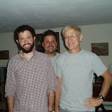
In any case her worker transported me to Asheville where I picked up the rental car and drove to Black Mountain and my dinner with the Galloways. As for all new parents, they looked a little tired from sleep deprivation ; the visit, movie viewing, and meal was wonderful. AT, The Long Journey is fantastic and an excellent depiction of the rigors one goes through to complete a thru-hike.
The following day, I drove the 7 hours to D.C. along the highways and made a startling observation. I curse far less at the young hikers who overtake me and cut me off on the AT, than I do in the car at drivers who display similar patterns of behavior. The meeting with ACG went well, and it was great to catch up with friends and now extended family. I thought that 7 days off the trail would do a world of good for my aching feet. Kathy and I with her friend Tracey, drove me back to the trail at Fontana after a brief visit with her family in Wilson, NC.
Kathy dropped me on the trail on April 19th back at the Fontana Dam, and we said our goodbyes. I will say that leaving her for extended periods is perhaps the greatest challenge of this hike. The weather was cool and beautiful as I entered the Smokies. A little yearling fawn came across my path within 15' and brought me to a standstill, and created an excellent Kodak moment. We kept the mileage the first day down to 14. That first night was beautiful with moon and stars. There was no need for a headlamp for the 2AM pee break! I did notice though that the feet were as sore and numb as ever despite the rest, with some of the pain stemming from plantar fasciitis, and neuropathy from my first thru-hike.
The following day I hiked within 7 miles of Clingman's Dome, at 6441, the highest point on the AT, and second highest mountain in the Appalachians behind Mt. Mitchell, also in North Carolina (Washington is a distant third!). With each hour that passed with hiking, the problem with my feet seemed to compound. Despite the new inserts, this did not seem to be a tenable situation if I expected to finish the trail. The only long term solution might be amputation, but trail surgeons are hard to come by. I called Kathy and actually made the arrangements to have her meet me at Newfound Gap the following day for pick-up. I felt at that moment that I needed to terminate the hike.
After speaking with her, I noted that my feet were much improved once I removed the boots and donned my Crocs. I texted her the next morning and told her to cancel the rescue mission and that I would make my way through the rest of the Smokies to Hot Springs, and there get new shoes and see where that left me and my feet; hopefully somewhere other than in the middle of nowhere unable to take another step. I am happy to say things have slowly improved day by day to 'tolerable'.
I called Kathy from the summit of Clingman's to confirm the new plan and admitted that I also swallowed my pride as well as 3 ibuprofen, which may have helped as well. The view from the mountain tower was beautiful. Unlike most mountains in the south which even at 550' are covered with hardwoods like White Oak, Clingman's is covered with pine trees. I spent most of the morning walking the ridgeline listening to the whispering pines and smelling that wonderful smell, thinking that this could easily be a ridge back in Maine. I was at Newfound Gap by 1:30; where I was greeted by hoards of tourists with cars, but no obvious trail magic. I sat down and painfully munched on my Builder Bar (ahh.. never again!). I was out of water, and despite the fact there were flush toilets at the gap, the only way I could conceivably refill my Camelback would have been to filter/pump water from the toilet... no potable water! So the last three miles to Icewater shelter were very thirsty, but fortunately the shelter lived up to it's name with a beautiful spring of ice cold water. I washed my head and torso with in a brief effort to clean myself with a PTA wash, and immediately began to shiver from hypothermia, driving me into my warmer clothes. That evening, a group of young hikers brought up three pounds of hot dogs with buns and mustard given to them by a gentleman who wanted to set up a trail magic dispensary, but was denied by the rangers. We set a fire, and had a weenie roast. It is amazing how much one is willing to compromise usual values and practices on the trail due to starvation. On any other given day, I wouldn't give a hot dog a second look, but after 4 days in the wilderness, it tasted like filet mignon.
The next day some were up before dawn. Using the red light function on their headlamps made them look like aliens carefully assessing and packing gear while the rest of us slept. That day was wonderful hiking the northern razorbacks of the Smokies. There long gentle assents to narrow 'catwalks' between the sharp peaks. The trail at times was no more than two to three feet wide, with a sharp downslope on either side at 50'-60'. Most of these peaks were also pine covered and took me back to home in Maine. I spent a good portion of the day hiking with 'Hopper', a thirty something who had spent three semesters in Orono at the University and had spent some time at Schoodic catalogueing birds on the islands. I also hiked with Pterodactyl, a very humorous retired EMT from Hooksett NH, who was renamed by some of the other hikers, beer-o-dactyl. We arrived after 20 miles at Crosby Knob shelter, to one of the most crowded, (and bear infested), campsites to date. There was an ATC ridge runner there to direct people where to camp with a full shelter. With the prospect of heavy rain that night, I was not pleased with the option of camping and fortunately for me, the ridge-runner took pity on the elderly and squeezed the shelter inhabitants space just a little to allow for my entry. That night did bring rough storms and thunder storms. The rain had ceased by the following day, and allowed me to venture the .6 mile off trail to the fire tower on Mt. Cammert, purported to give one of the most spectacular views of the Smokies. The mountains to the south were not visible but Davenport gap was beautiful with advancing undercast. I watched as the fog crept up the mountain and finally engulfed us. With that, it began to pour, and continued to do so for the rest of the day on the hike down to Davenport Gap. When it's a warm rain, I'll usually keep my clothes dry and wear only the tennis ball yellow running shirt and running shorts. At one point I was overtaken by young hikers who had donned their rain parkas and pants. As they passed, one asked me how it was I was not using any rain gear. My reply was that I was multi-tasking, which elicited a quizzical look. I explained I was taking a shower, washing my clothes, and hiking at the same time. They just smiled and wished me a good hike.
I fortunately reached Standing Bear hiker hostel around 1PM, just as the rain came to an end. The hostel was one of my favorite stops nine years ago, but with the death of the first owner Curtis from pancreatic cancer last year, the place was being managed by one of his friends 'Lumpy', who did not appears to care for hikers or take an active interest in keeping the place in good repair. I tried to joke around with Lumpy on one or two occasions, but was stopped cold in my tracks. He reportedly screamed a hiker for taking his picture, with the comment 'how do you know there are no wanted criminals here?' Not a friendly guy and the place was trashed. I did a full sink-load of dishes (leave a place better than what you found it, boy scout motto #99).
The next day out of Davenport was cool and foggy for most of the day with a threat of rain. We made our way back up to 5800 feet and over several balds. By the time I reached Max Patch, the view had cleared and was magnificent. At the bottom of the bald, we met a group of campers, 'hiker-Trash, 2014 reunion', a group of thru-hikers from 2014 who came back to give a weekend of trail magic. I enjoyed a helping of beans and chips with soda as a break for lunch. Nice people who really impressed me with their love of the trail and their desire to 'pass it on down', the kindness they too had been shown on their hike. Truly humbling!
I did push on to finish my second 20 mile day that day to Walnut Mountain. I was the only one to stay in the ancient mouse-infested shelter, as everyone else set up a tent. After initial fruitless investigations in the early evening though, the mice left me alone the rest of the night. The shelter is located near another small bald and afforded incredible images at sunset and sunrise. Here I met a father-daughter pair from old stomping grounds of Woodsville NH. He was also a retired EMT, and she was a ward secretary at Cottage Hospital.
The following day I made the final 13 mile trek here, along the way climbing another 800' over Bluff Mountain and more spectacular views of the valleys below and the mountain to come to the north. So here we are enjoying a day of relaxation, allowing for this next installment. Until next time...?


We have reached the 175 mile mark here in Hot Springs, with less than 2000 miles to go! There is only one problem; Hot Springs is a little hotter than usual, as there is a forest fire in the vicinity of the northbound trail leading out of town. I thought I left the Smokies behind me, but that was not entirely true! There are helicopters, planes with fire retardants, and ground fighters 'hot shots' here to fight the blaze which started under suspicious circumstances. From town you can see smoke from time to time, and 2600 acres of scorched hillsides above the town. Three theories are postulated: 1, a group of hikers stealth camping by the river started a campfire then left to go to town for a night on the town , and the fire got away into the surrounding woods. 2, a group of anarchist 'rainbow' hippie hikers (a real thing apparently) started the fire. 3, Last Wednesday there was a drunk hiker who was accosted by the local gendarme and at the conclusion of this interaction, the hiker was heard to say 'I'm going to burn your town to the ground!' The hikers have their own theory which is that the fire was started by the local merchants to boost sales. All theories are being actively investigated by the local authorities.
In any case, I am taking a 'zero' day today, buying new shoes and resting for the next section of the hike. Tomorrow I'll be bused to Allen Gap via a shuttle to get around the burn zone, missing 15 miles of the trail. I am staying ant the Sunnyside Inn, run by Elmer, who hiked the trail in 1978, then returned here and bought the Victorian mansion and converted it to the hostel. I stayed in the Earl Schafer room, the first person to thru-hike in 1948, and repeated the hike in 1998 at age 80. He stayed both times in Hot Springs in the room I am now enjoying. After his first hike, the ATC did not believe him or that a thru-hike was even possible. He actually had to give a slide presentation to ATC to prove his claim! What a trend-setter, with now more than 5000 people starting an intended thru-hike. ATC never sent Earl the 2000 miler patch the first time though.
As I have mentioned before hiking the trail is like taking a ride on a cruise liner... well not really but they seem to both have a perennial problem with Norovirus. This is a nasty bug the gives severe heaves, vomiting and diarrhea for 24-48 hrs. It has reappeared for the last 5-6 years on the AT and spreads north with the bubble of hikers. Donna my hostess at Cabin in the Woods, had picked up several prostrate hikes in Fontana and brought them to the resort to be housed and watched. She called me the morning of my shuttle to let me know that she too had been infected, and I might be at risk. Despite breaking bread with her at her dinner table on several occasions I can happily report that so far I have escaped the contagion.
In any case her worker transported me to Asheville where I picked up the rental car and drove to Black Mountain and my dinner with the Galloways. As for all new parents, they looked a little tired from sleep deprivation ; the visit, movie viewing, and meal was wonderful. AT, The Long Journey is fantastic and an excellent depiction of the rigors one goes through to complete a thru-hike.
The following day, I drove the 7 hours to D.C. along the highways and made a startling observation. I curse far less at the young hikers who overtake me and cut me off on the AT, than I do in the car at drivers who display similar patterns of behavior. The meeting with ACG went well, and it was great to catch up with friends and now extended family. I thought that 7 days off the trail would do a world of good for my aching feet. Kathy and I with her friend Tracey, drove me back to the trail at Fontana after a brief visit with her family in Wilson, NC.
Kathy dropped me on the trail on April 19th back at the Fontana Dam, and we said our goodbyes. I will say that leaving her for extended periods is perhaps the greatest challenge of this hike. The weather was cool and beautiful as I entered the Smokies. A little yearling fawn came across my path within 15' and brought me to a standstill, and created an excellent Kodak moment. We kept the mileage the first day down to 14. That first night was beautiful with moon and stars. There was no need for a headlamp for the 2AM pee break! I did notice though that the feet were as sore and numb as ever despite the rest, with some of the pain stemming from plantar fasciitis, and neuropathy from my first thru-hike.
The following day I hiked within 7 miles of Clingman's Dome, at 6441, the highest point on the AT, and second highest mountain in the Appalachians behind Mt. Mitchell, also in North Carolina (Washington is a distant third!). With each hour that passed with hiking, the problem with my feet seemed to compound. Despite the new inserts, this did not seem to be a tenable situation if I expected to finish the trail. The only long term solution might be amputation, but trail surgeons are hard to come by. I called Kathy and actually made the arrangements to have her meet me at Newfound Gap the following day for pick-up. I felt at that moment that I needed to terminate the hike.
After speaking with her, I noted that my feet were much improved once I removed the boots and donned my Crocs. I texted her the next morning and told her to cancel the rescue mission and that I would make my way through the rest of the Smokies to Hot Springs, and there get new shoes and see where that left me and my feet; hopefully somewhere other than in the middle of nowhere unable to take another step. I am happy to say things have slowly improved day by day to 'tolerable'.
I called Kathy from the summit of Clingman's to confirm the new plan and admitted that I also swallowed my pride as well as 3 ibuprofen, which may have helped as well. The view from the mountain tower was beautiful. Unlike most mountains in the south which even at 550' are covered with hardwoods like White Oak, Clingman's is covered with pine trees. I spent most of the morning walking the ridgeline listening to the whispering pines and smelling that wonderful smell, thinking that this could easily be a ridge back in Maine. I was at Newfound Gap by 1:30; where I was greeted by hoards of tourists with cars, but no obvious trail magic. I sat down and painfully munched on my Builder Bar (ahh.. never again!). I was out of water, and despite the fact there were flush toilets at the gap, the only way I could conceivably refill my Camelback would have been to filter/pump water from the toilet... no potable water! So the last three miles to Icewater shelter were very thirsty, but fortunately the shelter lived up to it's name with a beautiful spring of ice cold water. I washed my head and torso with in a brief effort to clean myself with a PTA wash, and immediately began to shiver from hypothermia, driving me into my warmer clothes. That evening, a group of young hikers brought up three pounds of hot dogs with buns and mustard given to them by a gentleman who wanted to set up a trail magic dispensary, but was denied by the rangers. We set a fire, and had a weenie roast. It is amazing how much one is willing to compromise usual values and practices on the trail due to starvation. On any other given day, I wouldn't give a hot dog a second look, but after 4 days in the wilderness, it tasted like filet mignon.
The next day some were up before dawn. Using the red light function on their headlamps made them look like aliens carefully assessing and packing gear while the rest of us slept. That day was wonderful hiking the northern razorbacks of the Smokies. There long gentle assents to narrow 'catwalks' between the sharp peaks. The trail at times was no more than two to three feet wide, with a sharp downslope on either side at 50'-60'. Most of these peaks were also pine covered and took me back to home in Maine. I spent a good portion of the day hiking with 'Hopper', a thirty something who had spent three semesters in Orono at the University and had spent some time at Schoodic catalogueing birds on the islands. I also hiked with Pterodactyl, a very humorous retired EMT from Hooksett NH, who was renamed by some of the other hikers, beer-o-dactyl. We arrived after 20 miles at Crosby Knob shelter, to one of the most crowded, (and bear infested), campsites to date. There was an ATC ridge runner there to direct people where to camp with a full shelter. With the prospect of heavy rain that night, I was not pleased with the option of camping and fortunately for me, the ridge-runner took pity on the elderly and squeezed the shelter inhabitants space just a little to allow for my entry. That night did bring rough storms and thunder storms. The rain had ceased by the following day, and allowed me to venture the .6 mile off trail to the fire tower on Mt. Cammert, purported to give one of the most spectacular views of the Smokies. The mountains to the south were not visible but Davenport gap was beautiful with advancing undercast. I watched as the fog crept up the mountain and finally engulfed us. With that, it began to pour, and continued to do so for the rest of the day on the hike down to Davenport Gap. When it's a warm rain, I'll usually keep my clothes dry and wear only the tennis ball yellow running shirt and running shorts. At one point I was overtaken by young hikers who had donned their rain parkas and pants. As they passed, one asked me how it was I was not using any rain gear. My reply was that I was multi-tasking, which elicited a quizzical look. I explained I was taking a shower, washing my clothes, and hiking at the same time. They just smiled and wished me a good hike.
I fortunately reached Standing Bear hiker hostel around 1PM, just as the rain came to an end. The hostel was one of my favorite stops nine years ago, but with the death of the first owner Curtis from pancreatic cancer last year, the place was being managed by one of his friends 'Lumpy', who did not appears to care for hikers or take an active interest in keeping the place in good repair. I tried to joke around with Lumpy on one or two occasions, but was stopped cold in my tracks. He reportedly screamed a hiker for taking his picture, with the comment 'how do you know there are no wanted criminals here?' Not a friendly guy and the place was trashed. I did a full sink-load of dishes (leave a place better than what you found it, boy scout motto #99).
The next day out of Davenport was cool and foggy for most of the day with a threat of rain. We made our way back up to 5800 feet and over several balds. By the time I reached Max Patch, the view had cleared and was magnificent. At the bottom of the bald, we met a group of campers, 'hiker-Trash, 2014 reunion', a group of thru-hikers from 2014 who came back to give a weekend of trail magic. I enjoyed a helping of beans and chips with soda as a break for lunch. Nice people who really impressed me with their love of the trail and their desire to 'pass it on down', the kindness they too had been shown on their hike. Truly humbling!
I did push on to finish my second 20 mile day that day to Walnut Mountain. I was the only one to stay in the ancient mouse-infested shelter, as everyone else set up a tent. After initial fruitless investigations in the early evening though, the mice left me alone the rest of the night. The shelter is located near another small bald and afforded incredible images at sunset and sunrise. Here I met a father-daughter pair from old stomping grounds of Woodsville NH. He was also a retired EMT, and she was a ward secretary at Cottage Hospital.
The following day I made the final 13 mile trek here, along the way climbing another 800' over Bluff Mountain and more spectacular views of the valleys below and the mountain to come to the north. So here we are enjoying a day of relaxation, allowing for this next installment. Until next time...?
Monday, April 11, 2016
Monday, April 11, 2016 Fontana Dam, North Carolina
Well eight days have elapsed and a hundred miles since my last post. Here we are though at the southern gateway to the Great Smoky Mountain National Park, 71 miles of gorgeous hiking that includes the highest point on the AT, Klingman's Dome . Unfortunately at this juncture, I need to take a hiatus for the next several days to find my way to Washington, D.C. for a College of Gastroenterology Governor's meeting and lobbying on the hill; even here, some aspects of work can still call.
The last week hs been exceptionally cold as a polar vortex, only the second one of the winter has descended on the eastern US plunging temps 15 - 20' below normal. The first week we had daytime temps above 65', and for the last week, some days were not out of the 30's. This has driven some hikers to the security of towns and hostels, myself included.
After leaving Hiawassee, I was dropped with several other fellow hikers at Unicoi Gap at 3000' The next 16 miles to Dick's Creek Gap is known as the toughest stretch in Georgia, and includes the highest point on the AT in Georgia, Mt. Trey. We set out with other hikers with such colorful names as Wild Horses (whose real name is Morgan, Cheddah, and a Brit who goes by Double O (007). I felt good and strong with a day in town refreshing my constitution, a sentiment shared by my fellows. By 11:45, we had climbed Trey Mountain to have lunch with a perfect view in the cold crisp air. We ran into volcano, a 70 year old on his 4rth attempt to finally finish a thru-hike, having been thwarted by medical issues on previous attempts. He spent the night at Trey, and told us the wind chill had fallen to 10 - 15' overnight. No one froze to death but many at the shelter thought they were. At the top, we also met once again executive, a Delta airlines pilot who lives in Lynn, Ma., and does section hikes with a light pack all along the trail. After lunch, he promised he would bring two days of trail magic in Maine to Antlers campsite, in August and by float plane... awesome!
Although my companions decided to stop at Addis Gap to camp, my original plan was to continue to Deep Gap and a shelter. On the way, I passed a crew of about 12 Boy Scouts who were headed for the same destination. I found out later that they arrived at the shelter at sundown, finding the place swamped with people as have most shelter sites been since the start. Knowing that there would be a high volume of campers, I continued on the the Disk' Creek Gap, the next major road crossing. On the way, I hiked and got to know somewhat 'puck', who at an age in his early 40's, had retired from the Marines after 22 years where he was a sniper, and personally knew the larger than life figure Chris Kyle, the American Sniper! He was now hiking the trail, before the next chapter of his life would sweep away any free time. We both reached the gap, and walked the half mile to the Top of Georgia hostel, a wonderful 3 year old hostel built and run by Bob. Puck got the last mattress inside and I volunteered to sleep outside in my tent. Once again the night proved to be a chilly one.
After a hostel breakfast of home-made muffins and coffee, we continued on our way, once again facing a 1000' climb out of the gap. This day was marked by crossing the Georgia boarder into North Carolina, 75 miles and one state down. After reaching Bly Gap, and the gnarly tree, I faced an incredibly hard climb to 4000'. After an arduous day, I reached Standing Indian Shelter by 6:30, and shared the shelter with three or four other young hikers I had met at TOG. An early bed at sunset called me.
Once again, the next day was clear and cold, around the freezing mark. The climb up Standing Indian Mountain proved much easier tan expected and provided magnificent morning views. I met a couple on top who braved the cold and camped there, rewarded by seeing the sunrise from the summit.
The second mountain of the day, Mt. Albert, proved to be much more difficult and taxing. The last 200' guided us through a boulder field at 45' incline, and requires all four extremities to guide you safely to the top. From there I descended the mountain a last 2.6 miles to a new beautiful shelter at Long Branch, recently constructed of post and beam and capable of holding 16 hikers. Even then, there were at least another 6 tents set up outside for the 'overflow. There I once again ran into Olivia, Kira, and their husky, Glacier, who I had met and hiked with briefly at Low Gap. They had found a stray dog in the mountains, obviously lost by another hiker, and were bringing the dog to the next town, Franklin. At this stop, I soaked my aching feet in the 45' stream, which initially was numbingly painful, but after removal, made a bid difference in comfort level. There we also met Pharmacy, so dubbed because of the drugs he had brought for a cold, and Little Brother.
We were all excited to awake the next day to a shorter hike of 7.5 miles to Winding Stair Gap, and a town visit to Franklin, to restock, refresh, and enjoy libation. The timing was perfect as a cold rain was forecast for that night.I reached the gap, sitting alone by 11:30. This was a major highway over the mountains. A free shuttle manned by legendary Ron Haven serendipitously arrived picking up other hikers from the previous Wallace Gap. He gave us the tour of Franklin, and told us we were not obliged to stay at his budget inn, but if you did, the perks included... it was cheap and easy! I went to local outfitter and described my feet neuropathy issue with a very knowledgeable manager who suggested hot mouldable inserts. Since then, my feet have been so much better, and this may have made the difference of whether or not I'll be able to finish this hike!
The next day we were shuttled to the First Baptist Church for a free hiker pancake breakfast. These were very nice people who do this every year daily for 2-3 weeks at the peak of hiker traffic. After that, Ron shuttled us back to the gap, wishing us well. by 9:30. The day startes sunny after passage of precipitation overnight, The front however brought in a reinforcing shot of cold air, and skies got more cloudy as the day went on and threatened rain, then snow. We had magnificent views over Siler's Bald, and Wyah Bald. Bald are naturally occurring grassy areas that have been open and treeless since before colonial times. The early settlers brought their livestock to graze there. I arrived at Clear Spring Shelter, a shelter built in 1933 with a capacity of 6, and was the 6th person there. One or two of the younger hikers were not happy that I had arrived to occupy this spot ahead of their companions. Ah well, guess they just have to hike faster than an old man. These male young hikers proved to be very immature, and did not hold back vulgarity from the two women who also stayed there, whom they did not really know. One of the young women was from Vermont, hiking the trail alone, but meticulously. The boys had no stoves, and started a fire. Cooking consisted of throwing a 12' tortilla on the open fire for 10 seconds, retrieving it, then flipping and repeating the process while heating pepperoni and cheese to fill said tortilla on a flat rock. Guess they dropped out of scouting before completing the second class cooking requirement!
The night was windy, rough and cold a stretched my 30' sleeping bag to the limits of what I would call comfortable, even wearing some clothing to bed. Sleep was fitful and not restful. We awoke in the morning to a thin layer of powder snow. One of the boys had left their Sawyer filter outside and it split with freezing. After the others had arisen and cleared space, I took my usual fare of pop-tart and oatmeal, then packed and got underway and span the 12 mile to the NOC, Nantahala Outdoor Center. My Friend Puck had arrived late that night and camped near the shelter, so we were able to reconnect on the trail. The final 5 miles down to NOC was difficult and unending, losing over 3000' feet of elevation. We booked a bunk and shower for the night, and took advantage of the good restaurant on the premises. There I met another older hiker in his mid 50's, 'Slow-Lane', from Anchorage. I had dinner with Puck which consisted of a large Greek salad. Trail cravings were starting to kick in.
The next day, after starting the day with a breakfast burrito,we once again faced the 3000' climb out of NOC. It was still windy and cold, with the temps never getting out of the high 30's. After stopping for lunch at Sassafras Shelter, I met a pair of hikers, Crisco and Twinkle Toes, who were Dartmouth '17, and had taken two terms off to do the trail. He had earned his name as he had brought crisco to add to the evening meal and add calories, but he soon discovered, it did not add much flavor! At 4:30, I reached Stecoah Gap and a wonderful family doing trail magic of hot dogs, beans, potato salad,... Hopeful was an older local gentleman in charge who had also done the trail twice in 2003 and 2011. His trip in 2011 was almost brought to a halt in the northeast by hurricane Irene. As the night ahead promised one of the coldest nights to date, three of us called the hostel, Cabin in the Woods run by Donna, who came and picked us up. She has a beautiful main log house home with several smaller cabins all equipped with TV, running water, showers etc... all the amenities of home. For an extra $8 she provides you with a home-made dinner, and $5 will get you Breakfast. She is like a mother figure at age 73 and loves her hikers. I decided to stay here two night, and slack-packed the last 15 miles to Fontana.
So today was a rest day, and Donna will shuttle me to Asheville tomorrow. There I will have dinner with Chris Galloway and his wife who hiked the trail in 2013 and composed a brilliant movie, AT, the long jouney. In exchange for financial help, my reward is dinner at his house and a viewing of the movie. The clips I have seen really capture what it means to face the hardships of hiking the AT. I'll expect to resume my jouney in 6 or 7 days... till then.
Saturday, April 2, 2016
April 2, 2016. Hiawassee, Ga. Four days of hiking the AT from Springer Mt. Have brought me 51 miles to here. I was expecting to continue one more day and get off at Duck's Creek, but more feet problems than expected have brought me to town for a little rest and a lot of first aid. How does one get a blister under a toe nail????
So far the biggest difference between now and 9 years ago is the numbers of hikers. I spent the first night at Gooch Shelter and there must have been 50 hikers there. There does seem to be more of a party attitude now and from some, less respect for the trail and their impact there as evidenced by a significant amount of litter. When possible, l have already policed and carried out trash I have found along the way.
I arrived in Atlanta without much problem to 70' temps and green landscapes. Carl, a hostel worker for Josh and Leigh Saint, picked me up from the train and brought 5 of us to the hostel. Carl and his wife Duffy work at the AT Inn in Millinocket as cooks and shuttle drivers as well during the summer months.
The first day from Springer was a spectacular day and I was able to cover over 16 miles to Gooch Shelter. Much of the day I hiked with Bill, a retired engineer from upstate New York, who at age 66 could outpace many of the younger hikers. The day was crystal clear , unlike 9 years ago when a snowstorm hit us 2 days in. This time the warm dry temps lead me to mild dehydration over Sassafras mountain, not realizing the lack of springs or streams over a 5 mile stretch. Luckily at Cooper gap, the Army left a water hog for hikers which saved the day.
Once I reached 16 miles to Gooch shelter, I got to set up the new tent. Thank God for u-tube videos. Flat ground was in short supply and the talking by other hikers went well past 11pm. I barely noticed as I was in bed and asleep at sundown around 8:30.
Awoke to a waxing half moon but also the start of a haze in the sky telling me that I could expect changes in the weather. I arose, packed and had the standard AT breakfast of two poptarts, two instant oatmeal, and Starbucks mocha via; around 800 calories in all. Estimates are that one expends 4000 to 6000 cal/day on the AT. You can't carry that much food for a 4-6 day stretch between towns, so while you're resupplying in town, you look for low weight calorie dense foods; not that hard in America!
Bill went out ahead of me and really did not see him again until the end of the day at Blood Mtn.
Along the way I hiked with a young man from Baltimore, Silly Moose, who had sectioned hiked in Maine and had also done the Long Trail in Vermont. Also met two older gents from Texas who seemed to be struggling at 5 days into their thru-hike which they were using as a fundraiser for Optimus Foundation.
Lots of people on Blood Mountain and picture opportunities for me and Wilson, my trusty traveling tennis ball companion. From there it was a short run of 1.5 miles to Neels gap (mile 33 from Springer) and the Walysi Center and hostel where I found a bunk and a shower.
The next day was cloudy and misty. You could feel the threat of rain. Even the air was thick to breathe and seemed less capable of satisfying your oxygen deprivation. A half mile up the trail, I realized I had not checked off in my mind my camera as being packed, and this was confirmed by emptying out the pack there on the trail. A quick return to the center and we found it on the window sill. The hostel workers told me they also found two cell phones. I am glad I discovered my mistake when I did, rather than 9 miles down the trail. The little mishap did cost 45' in all!
Most of the day till 2pm is best described as showers, and I did not get that wet. All that changed with the deluge in the late afternoon. The contents of the backpack stayed dry but me and everything else was soaked. We arrived at Low Gap shelter at 3:30. There were already several tents set up as people hunkered down to weather the storm. By some miracle of providence, as I arrived, another hiker was just leaving the shelter, preferring to face the weather and another 7 miles to the next shelter. He apparently preferred this over remaining in the present shelter where he had engaged in a not-so-pleasant political discussion with three other section hikers. His departure was my opening to the shelter. The rain stopped for a while a dusk, only to reinvigorate itself into a thunder and lightning display of great magnitude over night. At times, being in a shelter is good !
The next day brought short lived showers in the morning, as well as dense mist. As the day went on the sun made its appearance again and started to dry my wet clothing and boots. I had a great lunch at Blue Mountain shelter with a spectacular view of the mountains. Though I had planned to hike through Unicoi gap and camp one more night before going into town at Hiawassee, my feet and the prospect of another hot shower prevailed, and we opted to go to town and take a 'zero' to allow the feet a little rest and recovery after some intensive fist aid.
So today I am hanging out, doing laundry and catching up with blogging. I am staying at the Hiawassee budget inn, the finest the south can offer where a hikers bash is scheduled tonight and over 200 current and previous thru-hikers are expected to attend free food (pulled pork), and blue grass music. We,'ll see how much sleep I get tonight. I may have wished I had gone back to the trail!
Subscribe to:
Posts (Atom)