Monday, April 11, 2016 Fontana Dam, North Carolina
Well eight days have elapsed and a hundred miles since my last post. Here we are though at the southern gateway to the Great Smoky Mountain National Park, 71 miles of gorgeous hiking that includes the highest point on the AT, Klingman's Dome . Unfortunately at this juncture, I need to take a hiatus for the next several days to find my way to Washington, D.C. for a College of Gastroenterology Governor's meeting and lobbying on the hill; even here, some aspects of work can still call.
The last week hs been exceptionally cold as a polar vortex, only the second one of the winter has descended on the eastern US plunging temps 15 - 20' below normal. The first week we had daytime temps above 65', and for the last week, some days were not out of the 30's. This has driven some hikers to the security of towns and hostels, myself included.
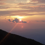
After leaving Hiawassee, I was dropped with several other fellow hikers at Unicoi Gap at 3000' The next 16 miles to Dick's Creek Gap is known as the toughest stretch in Georgia, and includes the highest point on the AT in Georgia, Mt. Trey. We set out with other hikers with such colorful names as Wild Horses (whose real name is Morgan, Cheddah, and a Brit who goes by Double O (007). I felt good and strong with a day in town refreshing my constitution, a sentiment shared by my fellows. By 11:45, we had climbed Trey Mountain to have lunch with a perfect view in the cold crisp air. We ran into volcano, a 70 year old on his 4rth attempt to finally finish a thru-hike, having been thwarted by medical issues on previous attempts. He spent the night at Trey, and told us the wind chill had fallen to 10 - 15' overnight. No one froze to death but many at the shelter thought they were. At the top, we also met once again executive, a Delta airlines pilot who lives in Lynn, Ma., and does section hikes with a light pack all along the trail. After lunch, he promised he would bring two days of trail magic in Maine to Antlers campsite, in August and by float plane... awesome!
Although my companions decided to stop at Addis Gap to camp, my original plan was to continue to Deep Gap and a shelter. On the way, I passed a crew of about 12 Boy Scouts who were headed for the same destination. I found out later that they arrived at the shelter at sundown, finding the place swamped with people as have most shelter sites been since the start. Knowing that there would be a high volume of campers, I continued on the the Disk' Creek Gap, the next major road crossing. On the way, I hiked and got to know somewhat 'puck', who at an age in his early 40's, had retired from the Marines after 22 years where he was a sniper, and personally knew the larger than life figure Chris Kyle, the American Sniper! He was now hiking the trail, before the next chapter of his life would sweep away any free time. We both reached the gap, and walked the half mile to the Top of Georgia hostel, a wonderful 3 year old hostel built and run by Bob. Puck got the last mattress inside and I volunteered to sleep outside in my tent. Once again the night proved to be a chilly one.
After a hostel breakfast of home-made muffins and coffee, we continued on our way, once again facing a 1000' climb out of the gap. This day was marked by crossing the Georgia boarder into North Carolina, 75 miles and one state down. After reaching Bly Gap, and the gnarly tree, I faced an incredibly hard climb to 4000'. After an arduous day, I reached Standing Indian Shelter by 6:30, and shared the shelter with three or four other young hikers I had met at TOG. An early bed at sunset called me.
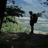
Once again, the next day was clear and cold, around the freezing mark. The climb up Standing Indian Mountain proved much easier tan expected and provided magnificent morning views. I met a couple on top who braved the cold and camped there, rewarded by seeing the sunrise from the summit.
The second mountain of the day, Mt. Albert, proved to be much more difficult and taxing. The last 200' guided us through a boulder field at 45' incline, and requires all four extremities to guide you safely to the top. From there I descended the mountain a last 2.6 miles to a new beautiful shelter at Long Branch, recently constructed of post and beam and capable of holding 16 hikers. Even then, there were at least another 6 tents set up outside for the 'overflow. There I once again ran into Olivia, Kira, and their husky, Glacier, who I had met and hiked with briefly at Low Gap. They had found a stray dog in the mountains, obviously lost by another hiker, and were bringing the dog to the next town, Franklin. At this stop, I soaked my aching feet in the 45' stream, which initially was numbingly painful, but after removal, made a bid difference in comfort level. There we also met Pharmacy, so dubbed because of the drugs he had brought for a cold, and Little Brother.
We were all excited to awake the next day to a shorter hike of 7.5 miles to Winding Stair Gap, and a town visit to Franklin, to restock, refresh, and enjoy libation. The timing was perfect as a cold rain was forecast for that night.I reached the gap, sitting alone by 11:30. This was a major highway over the mountains. A free shuttle manned by legendary Ron Haven serendipitously arrived picking up other hikers from the previous Wallace Gap. He gave us the tour of Franklin, and told us we were not obliged to stay at his budget inn, but if you did, the perks included... it was cheap and easy! I went to local outfitter and described my feet neuropathy issue with a very knowledgeable manager who suggested hot mouldable inserts. Since then, my feet have been so much better, and this may have made the difference of whether or not I'll be able to finish this hike!
The next day we were shuttled to the First Baptist Church for a free hiker pancake breakfast. These were very nice people who do this every year daily for 2-3 weeks at the peak of hiker traffic. After that, Ron shuttled us back to the gap, wishing us well. by 9:30. The day startes sunny after passage of precipitation overnight, The front however brought in a reinforcing shot of cold air, and skies got more cloudy as the day went on and threatened rain, then snow. We had magnificent views over Siler's Bald, and Wyah Bald. Bald are naturally occurring grassy areas that have been open and treeless since before colonial times. The early settlers brought their livestock to graze there. I arrived at Clear Spring Shelter, a shelter built in 1933 with a capacity of 6, and was the 6th person there. One or two of the younger hikers were not happy that I had arrived to occupy this spot ahead of their companions. Ah well, guess they just have to hike faster than an old man. These male young hikers proved to be very immature, and did not hold back vulgarity from the two women who also stayed there, whom they did not really know. One of the young women was from Vermont, hiking the trail alone, but meticulously. The boys had no stoves, and started a fire. Cooking consisted of throwing a 12' tortilla on the open fire for 10 seconds, retrieving it, then flipping and repeating the process while heating pepperoni and cheese to fill said tortilla on a flat rock. Guess they dropped out of scouting before completing the second class cooking requirement!
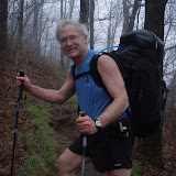
The night was windy, rough and cold a stretched my 30' sleeping bag to the limits of what I would call comfortable, even wearing some clothing to bed. Sleep was fitful and not restful. We awoke in the morning to a thin layer of powder snow. One of the boys had left their Sawyer filter outside and it split with freezing. After the others had arisen and cleared space, I took my usual fare of pop-tart and oatmeal, then packed and got underway and span the 12 mile to the NOC, Nantahala Outdoor Center. My Friend Puck had arrived late that night and camped near the shelter, so we were able to reconnect on the trail. The final 5 miles down to NOC was difficult and unending, losing over 3000' feet of elevation. We booked a bunk and shower for the night, and took advantage of the good restaurant on the premises. There I met another older hiker in his mid 50's, 'Slow-Lane', from Anchorage. I had dinner with Puck which consisted of a large Greek salad. Trail cravings were starting to kick in.
The next day, after starting the day with a breakfast burrito,we once again faced the 3000' climb out of NOC. It was still windy and cold, with the temps never getting out of the high 30's. After stopping for lunch at Sassafras Shelter, I met a pair of hikers, Crisco and Twinkle Toes, who were Dartmouth '17, and had taken two terms off to do the trail. He had earned his name as he had brought crisco to add to the evening meal and add calories, but he soon discovered, it did not add much flavor! At 4:30, I reached Stecoah Gap and a wonderful family doing trail magic of hot dogs, beans, potato salad,... Hopeful was an older local gentleman in charge who had also done the trail twice in 2003 and 2011. His trip in 2011 was almost brought to a halt in the northeast by hurricane Irene. As the night ahead promised one of the coldest nights to date, three of us called the hostel, Cabin in the Woods run by Donna, who came and picked us up. She has a beautiful main log house home with several smaller cabins all equipped with TV, running water, showers etc... all the amenities of home. For an extra $8 she provides you with a home-made dinner, and $5 will get you Breakfast. She is like a mother figure at age 73 and loves her hikers. I decided to stay here two night, and slack-packed the last 15 miles to Fontana.
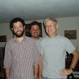
So today was a rest day, and Donna will shuttle me to Asheville tomorrow. There I will have dinner with Chris Galloway and his wife who hiked the trail in 2013 and composed a brilliant movie, AT, the long jouney. In exchange for financial help, my reward is dinner at his house and a viewing of the movie. The clips I have seen really capture what it means to face the hardships of hiking the AT. I'll expect to resume my jouney in 6 or 7 days... till then.
The Home Stretch

Hanover- Gorham 8/16/07
VT-NH pictures
More Pictures
Pictures: click here
Just Ryan, or "Tres"
The Maine-iacs: Mark "Uno" and Sean "Dewey"
No comments:
Post a Comment